You are here: Home > Network List > N4 - Central and EAstern US Network Stations List
> Station Q51A Peebles, OH, USA > Earthquake Result Viewer
Q51A Peebles, OH, USA - Earthquake Result Viewer
| Earthquake location: |
Northern East Pacific Rise |
| Earthquake latitude/longitude: |
8.3/-103.5 |
| Earthquake time(UTC): |
2019/01/18 (018) 16:40:42 GMT |
| Earthquake Depth: |
10 km |
| Earthquake Magnitude: |
6.0 Mww |
| Earthquake Catalog/Contributor: |
NEIC PDE/us |
|
| Network: |
N4 Central and EAstern US Network |
| Station: |
Q51A Peebles, OH, USA |
| Lat/Lon: |
39.03 N/83.35 W |
| Elevation: |
362 m |
|
| Distance: |
35.6 deg |
| Az: |
27.434 deg |
| Baz: |
215.832 deg |
| Ray Param: |
0.07715701 |
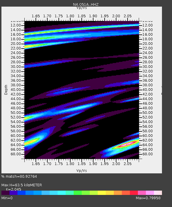
| Estimated Moho Depth: |
63.5 km |
| Estimated Crust Vp/Vs: |
2.05 |
| Assumed Crust Vp: |
6.232 km/s |
| Estimated Crust Vs: |
3.047 km/s |
| Estimated Crust Poisson's Ratio: |
0.34 |
|
| Radial Match: |
80.92764 % |
| Radial Bump: |
400 |
| Transverse Match: |
48.904934 % |
| Transverse Bump: |
400 |
| SOD ConfigId: |
13570011 |
| Insert Time: |
2019-05-02 08:06:49.279 +0000 |
| GWidth: |
2.5 |
| Max Bumps: |
400 |
| Tol: |
0.001 |
|

Signal To Noise
| Channel | StoN | STA | LTA |
| N4:Q51A: :HHZ:20190118T16:47:08.02999Z | 10.62621 | 9.781785E-7 | 9.205338E-8 |
| N4:Q51A: :HHN:20190118T16:47:08.02999Z | 2.5972972 | 5.5169085E-7 | 2.1240959E-7 |
| N4:Q51A: :HHE:20190118T16:47:08.02999Z | 2.5053172 | 5.285466E-7 | 2.1096993E-7 |
| Arrivals |
| Ps | 11 SECOND |
| PpPs | 29 SECOND |
| PsPs/PpSs | 41 SECOND |


