You are here: Home > Network List > OH - Ohio Seismic Network Stations List
> Station SSFO Shawnee State Forest Ohio > Earthquake Result Viewer
SSFO Shawnee State Forest Ohio - Earthquake Result Viewer
| Earthquake location: |
Northern East Pacific Rise |
| Earthquake latitude/longitude: |
8.3/-103.5 |
| Earthquake time(UTC): |
2019/01/18 (018) 16:40:42 GMT |
| Earthquake Depth: |
10 km |
| Earthquake Magnitude: |
6.0 Mww |
| Earthquake Catalog/Contributor: |
NEIC PDE/us |
|
| Network: |
OH Ohio Seismic Network |
| Station: |
SSFO Shawnee State Forest Ohio |
| Lat/Lon: |
38.70 N/83.20 W |
| Elevation: |
365 m |
|
| Distance: |
35.4 deg |
| Az: |
27.93 deg |
| Baz: |
216.33 deg |
| Ray Param: |
0.07726356 |
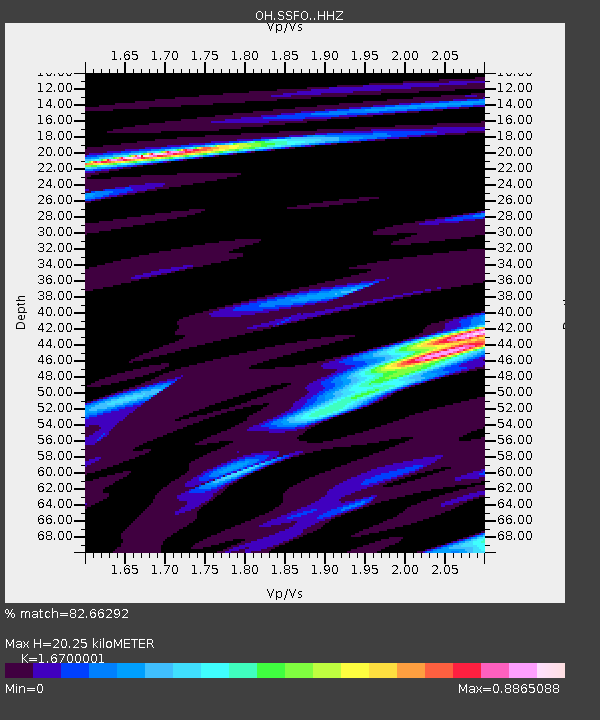
| Estimated Moho Depth: |
20.25 km |
| Estimated Crust Vp/Vs: |
1.67 |
| Assumed Crust Vp: |
6.232 km/s |
| Estimated Crust Vs: |
3.731 km/s |
| Estimated Crust Poisson's Ratio: |
0.22 |
|
| Radial Match: |
82.66292 % |
| Radial Bump: |
291 |
| Transverse Match: |
55.308872 % |
| Transverse Bump: |
346 |
| SOD ConfigId: |
13570011 |
| Insert Time: |
2019-05-02 08:07:36.304 +0000 |
| GWidth: |
2.5 |
| Max Bumps: |
400 |
| Tol: |
0.001 |
|

Signal To Noise
| Channel | StoN | STA | LTA |
| OH:SSFO: :HHZ:20190118T16:47:06.309989Z | 6.0249705 | 1.2912835E-6 | 2.1432197E-7 |
| OH:SSFO: :HHN:20190118T16:47:06.309989Z | 2.9163067 | 8.867918E-7 | 3.040804E-7 |
| OH:SSFO: :HHE:20190118T16:47:06.309989Z | 1.2409924 | 3.9662905E-7 | 3.1960633E-7 |
| Arrivals |
| Ps | 2.3 SECOND |
| PpPs | 8.0 SECOND |
| PsPs/PpSs | 10 SECOND |


