You are here: Home > Network List > TA - USArray Transportable Network (new EarthScope stations) Stations List
> Station C24A Savage, MT, USA > Earthquake Result Viewer
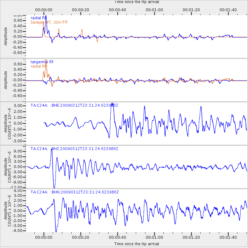
C24A Savage, MT, USA - Earthquake Result Viewer
*The percent match for this event was below the threshold and hence no stack was calculated.
| Earthquake location: |
South Of Panama |
| Earthquake latitude/longitude: |
5.7/-82.8 |
| Earthquake time(UTC): |
2009/03/12 (071) 23:23:34 GMT |
| Earthquake Depth: |
9.0 km |
| Earthquake Magnitude: |
6.1 MB, 5.9 MS, 6.3 MW, 6.2 MW |
| Earthquake Catalog/Contributor: |
WHDF/NEIC |
|
| Network: |
TA USArray Transportable Network (new EarthScope stations) |
| Station: |
C24A Savage, MT, USA |
| Lat/Lon: |
47.53 N/104.43 W |
| Elevation: |
713 m |
|
| Distance: |
45.6 deg |
| Az: |
339.525 deg |
| Baz: |
149.09 deg |
| Ray Param: |
$rayparam |
*The percent match for this event was below the threshold and hence was not used in the summary stack. |
|
| Radial Match: |
83.32444 % |
| Radial Bump: |
373 |
| Transverse Match: |
75.39673 % |
| Transverse Bump: |
378 |
| SOD ConfigId: |
2658 |
| Insert Time: |
2010-03-06 19:26:58.623 +0000 |
| GWidth: |
2.5 |
| Max Bumps: |
400 |
| Tol: |
0.001 |
|
Signal To Noise
| Channel | StoN | STA | LTA |
| TA:C24A: :BHZ:20090312T23:31:24.623986Z | 8.229587 | 3.7224336E-6 | 4.5232326E-7 |
| TA:C24A: :BHN:20090312T23:31:24.623986Z | 1.1667684 | 7.6212007E-7 | 6.5318875E-7 |
| TA:C24A: :BHE:20090312T23:31:24.623986Z | 1.456253 | 5.502702E-7 | 3.7786717E-7 |
| Arrivals |
| Ps | |
| PpPs | |
| PsPs/PpSs | |


