You are here: Home > Network List > US - United States National Seismic Network Stations List
> Station DGMT Dagmar, Montana, USA > Earthquake Result Viewer
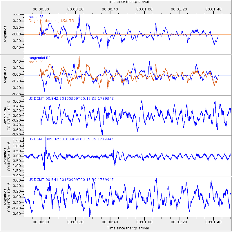
DGMT Dagmar, Montana, USA - Earthquake Result Viewer
*The percent match for this event was below the threshold and hence no stack was calculated.
| Earthquake location: |
Cordoba Province, Argentina |
| Earthquake latitude/longitude: |
-31.4/-65.7 |
| Earthquake time(UTC): |
2016/09/09 (253) 00:03:43 GMT |
| Earthquake Depth: |
151 km |
| Earthquake Magnitude: |
5.6 MWR |
| Earthquake Catalog/Contributor: |
NEIC PDE/NEIC COMCAT |
|
| Network: |
US United States National Seismic Network |
| Station: |
DGMT Dagmar, Montana, USA |
| Lat/Lon: |
48.47 N/104.20 W |
| Elevation: |
0.0 m |
|
| Distance: |
86.6 deg |
| Az: |
335.51 deg |
| Baz: |
147.819 deg |
| Ray Param: |
$rayparam |
*The percent match for this event was below the threshold and hence was not used in the summary stack. |
|
| Radial Match: |
63.451305 % |
| Radial Bump: |
400 |
| Transverse Match: |
57.86154 % |
| Transverse Bump: |
400 |
| SOD ConfigId: |
1634031 |
| Insert Time: |
2016-09-23 00:14:01.163 +0000 |
| GWidth: |
2.5 |
| Max Bumps: |
400 |
| Tol: |
0.001 |
|
Signal To Noise
| Channel | StoN | STA | LTA |
| US:DGMT:00:BHZ:20160909T00:15:39.173994Z | 3.9339197 | 5.664139E-7 | 1.4398208E-7 |
| US:DGMT:00:BH1:20160909T00:15:39.173994Z | 1.2123337 | 2.2776514E-7 | 1.8787331E-7 |
| US:DGMT:00:BH2:20160909T00:15:39.173994Z | 0.8695924 | 2.0333515E-7 | 2.3382812E-7 |
| Arrivals |
| Ps | |
| PpPs | |
| PsPs/PpSs | |


