You are here: Home > Network List > TA - USArray Transportable Network (new EarthScope stations) Stations List
> Station C24A Savage, MT, USA > Earthquake Result Viewer
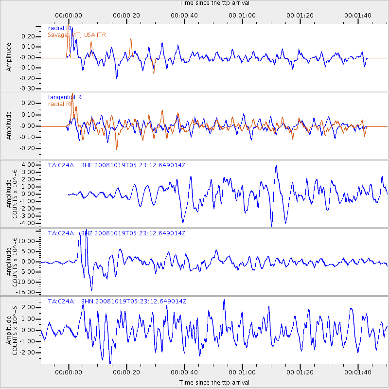
C24A Savage, MT, USA - Earthquake Result Viewer
*The percent match for this event was below the threshold and hence no stack was calculated.
| Earthquake location: |
Tonga Islands |
| Earthquake latitude/longitude: |
-21.9/-173.8 |
| Earthquake time(UTC): |
2008/10/19 (293) 05:10:33 GMT |
| Earthquake Depth: |
29 km |
| Earthquake Magnitude: |
6.8 MB, 7.0 MS, 6.9 MW, 6.9 MW |
| Earthquake Catalog/Contributor: |
WHDF/NEIC |
|
| Network: |
TA USArray Transportable Network (new EarthScope stations) |
| Station: |
C24A Savage, MT, USA |
| Lat/Lon: |
47.53 N/104.43 W |
| Elevation: |
713 m |
|
| Distance: |
92.9 deg |
| Az: |
39.429 deg |
| Baz: |
240.531 deg |
| Ray Param: |
$rayparam |
*The percent match for this event was below the threshold and hence was not used in the summary stack. |
|
| Radial Match: |
84.6945 % |
| Radial Bump: |
400 |
| Transverse Match: |
73.20109 % |
| Transverse Bump: |
400 |
| SOD ConfigId: |
2556 |
| Insert Time: |
2010-03-06 19:27:38.046 +0000 |
| GWidth: |
2.5 |
| Max Bumps: |
400 |
| Tol: |
0.001 |
|
Signal To Noise
| Channel | StoN | STA | LTA |
| TA:C24A: :BHZ:20081019T05:23:12.649014Z | 16.151505 | 5.0974695E-6 | 3.156034E-7 |
| TA:C24A: :BHN:20081019T05:23:12.649014Z | 1.6605232 | 7.6045507E-7 | 4.579611E-7 |
| TA:C24A: :BHE:20081019T05:23:12.649014Z | 1.9999199 | 9.587878E-7 | 4.7941313E-7 |
| Arrivals |
| Ps | |
| PpPs | |
| PsPs/PpSs | |


