You are here: Home > Network List > TA - USArray Transportable Network (new EarthScope stations) Stations List
> Station BRSD Miller, SD, USA > Earthquake Result Viewer
BRSD Miller, SD, USA - Earthquake Result Viewer
| Earthquake location: |
Southeast Of Honshu, Japan |
| Earthquake latitude/longitude: |
32.8/140.4 |
| Earthquake time(UTC): |
2009/08/12 (224) 22:48:51 GMT |
| Earthquake Depth: |
53 km |
| Earthquake Magnitude: |
6.2 MB, 6.6 MW, 6.6 MW |
| Earthquake Catalog/Contributor: |
WHDF/NEIC |
|
| Network: |
TA USArray Transportable Network (new EarthScope stations) |
| Station: |
BRSD Miller, SD, USA |
| Lat/Lon: |
44.44 N/98.96 W |
| Elevation: |
519 m |
|
| Distance: |
86.0 deg |
| Az: |
38.149 deg |
| Baz: |
313.437 deg |
| Ray Param: |
0.044240065 |
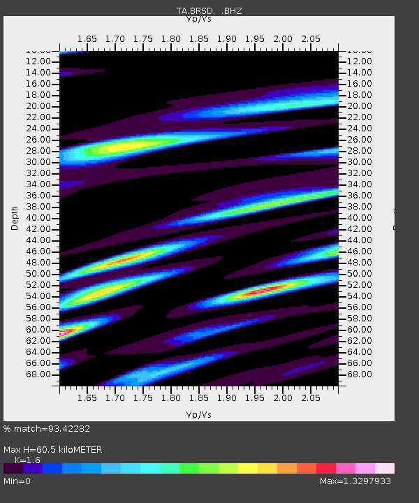
| Estimated Moho Depth: |
60.5 km |
| Estimated Crust Vp/Vs: |
1.60 |
| Assumed Crust Vp: |
6.53 km/s |
| Estimated Crust Vs: |
4.082 km/s |
| Estimated Crust Poisson's Ratio: |
0.18 |
|
| Radial Match: |
93.42282 % |
| Radial Bump: |
400 |
| Transverse Match: |
89.30055 % |
| Transverse Bump: |
400 |
| SOD ConfigId: |
2622 |
| Insert Time: |
2010-03-06 19:27:57.958 +0000 |
| GWidth: |
2.5 |
| Max Bumps: |
400 |
| Tol: |
0.001 |
|
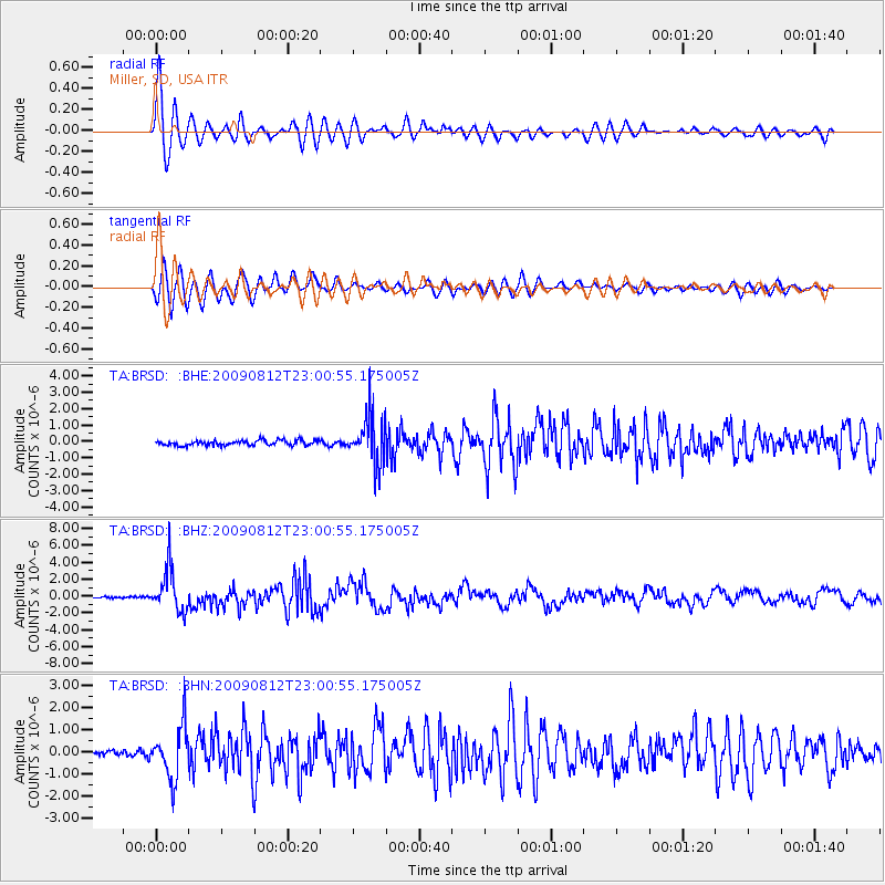
Signal To Noise
| Channel | StoN | STA | LTA |
| TA:BRSD: :BHZ:20090812T23:00:55.175005Z | 24.820662 | 2.5134682E-6 | 1.0126515E-7 |
| TA:BRSD: :BHN:20090812T23:00:55.175005Z | 7.5125933 | 1.1336837E-6 | 1.5090444E-7 |
| TA:BRSD: :BHE:20090812T23:00:55.175005Z | 9.413751 | 1.4896448E-6 | 1.5824136E-7 |
| Arrivals |
| Ps | 5.7 SECOND |
| PpPs | 23 SECOND |
| PsPs/PpSs | 29 SECOND |


