You are here: Home > Network List > TA - USArray Transportable Network (new EarthScope stations) Stations List
> Station BRSD Miller, SD, USA > Earthquake Result Viewer
BRSD Miller, SD, USA - Earthquake Result Viewer
| Earthquake location: |
Azores Islands Region |
| Earthquake latitude/longitude: |
36.2/-33.9 |
| Earthquake time(UTC): |
2009/11/04 (308) 18:41:44 GMT |
| Earthquake Depth: |
10 km |
| Earthquake Magnitude: |
5.7 MB, 5.6 MS, 5.9 MW, 5.8 MW |
| Earthquake Catalog/Contributor: |
WHDF/NEIC |
|
| Network: |
TA USArray Transportable Network (new EarthScope stations) |
| Station: |
BRSD Miller, SD, USA |
| Lat/Lon: |
44.44 N/98.96 W |
| Elevation: |
519 m |
|
| Distance: |
49.1 deg |
| Az: |
300.815 deg |
| Baz: |
76.015 deg |
| Ray Param: |
0.06888743 |
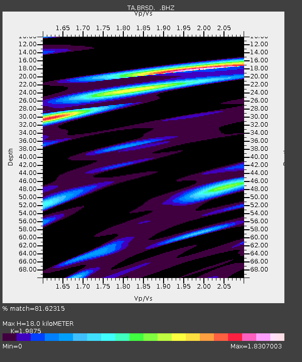
| Estimated Moho Depth: |
18.0 km |
| Estimated Crust Vp/Vs: |
1.99 |
| Assumed Crust Vp: |
6.53 km/s |
| Estimated Crust Vs: |
3.286 km/s |
| Estimated Crust Poisson's Ratio: |
0.33 |
|
| Radial Match: |
81.62315 % |
| Radial Bump: |
400 |
| Transverse Match: |
64.86422 % |
| Transverse Bump: |
400 |
| SOD ConfigId: |
2622 |
| Insert Time: |
2010-03-06 19:28:13.017 +0000 |
| GWidth: |
2.5 |
| Max Bumps: |
400 |
| Tol: |
0.001 |
|
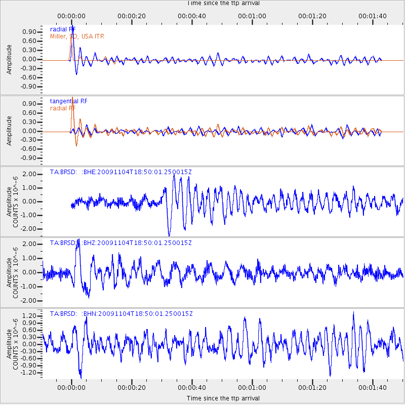
Signal To Noise
| Channel | StoN | STA | LTA |
| TA:BRSD: :BHZ:20091104T18:50:01.250015Z | 3.5711577 | 1.1682064E-6 | 3.271226E-7 |
| TA:BRSD: :BHN:20091104T18:50:01.250015Z | 2.5968072 | 6.8470973E-7 | 2.6367368E-7 |
| TA:BRSD: :BHE:20091104T18:50:01.250015Z | 5.0938234 | 1.2214322E-6 | 2.397869E-7 |
| Arrivals |
| Ps | 2.9 SECOND |
| PpPs | 7.8 SECOND |
| PsPs/PpSs | 11 SECOND |


