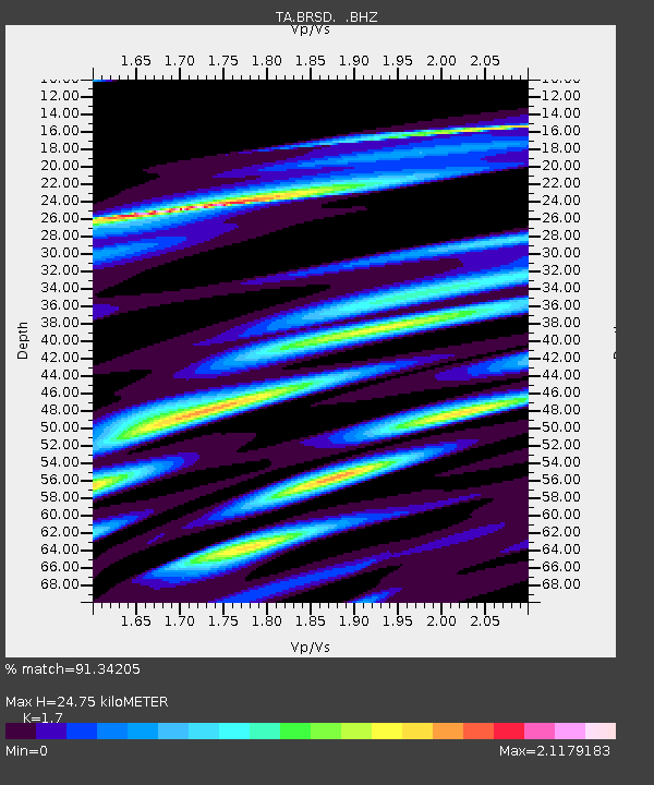
BRSD Miller, SD, USA - Earthquake Result Viewer
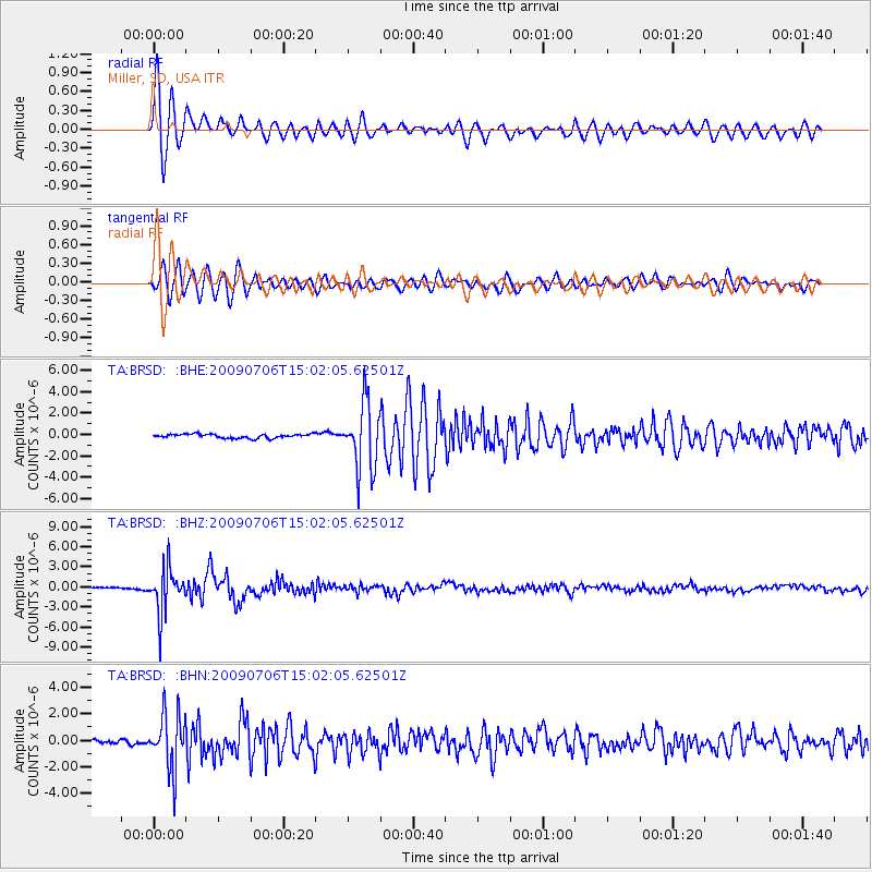
Earthquake location: Rat Islands, Aleutian Islands
Earthquake latitude/longitude: 50.4/177.0
Earthquake time(UTC): 2009/07/06 (187) 14:53:12 GMT
Earthquake Depth: 22 km
Earthquake Magnitude: 6.0 MB, 5.8 MS, 6.1 MW, 6.0 MW
Earthquake Catalog/Contributor: WHDF/NEIC
Network: TA USArray Transportable Network (new EarthScope stations)
Station: BRSD Miller, SD, USA
Lat/Lon: 44.44 N/98.96 W
Elevation: 519 m
Distance: 54.3 deg
Az: 61.354 deg
Baz: 308.417 deg
Ray Param: 0.065522924
Estimated Moho Depth: 24.75 km
Estimated Crust Vp/Vs: 1.70
Assumed Crust Vp: 6.53 km/s
Estimated Crust Vs: 3.841 km/s
Estimated Crust Poisson's Ratio: 0.24
Radial Match: 91.34205 %
Radial Bump: 400
Transverse Match: 89.63657 %
Transverse Bump: 400
SOD ConfigId: 2648
Insert Time: 2010-03-06 19:28:51.177 +0000
GWidth: 2.5
Max Bumps: 400
Tol: 0.001

Signal To Noise

ChannelStoNSTALTA
TA:BRSD: :BHZ:20090706T15:02:05.62501Z20.277933.3317901E-61.6430623E-7
TA:BRSD: :BHN:20090706T15:02:05.62501Z11.1871962.0807192E-61.8599113E-7
TA:BRSD: :BHE:20090706T15:02:05.62501Z16.6287363.107991E-61.8690483E-7
Arrivals
Ps2.8 SECOND
PpPs9.7 SECOND
PsPs/PpSs12 SECOND