You are here: Home > Network List > TA - USArray Transportable Network (new EarthScope stations) Stations List
> Station BRSD Miller, SD, USA > Earthquake Result Viewer
BRSD Miller, SD, USA - Earthquake Result Viewer
| Earthquake location: |
East Of Kuril Islands |
| Earthquake latitude/longitude: |
46.9/155.2 |
| Earthquake time(UTC): |
2009/01/15 (015) 17:49:39 GMT |
| Earthquake Depth: |
36 km |
| Earthquake Magnitude: |
6.9 MB, 7.5 MS, 7.4 MW, 7.4 MW |
| Earthquake Catalog/Contributor: |
WHDF/NEIC |
|
| Network: |
TA USArray Transportable Network (new EarthScope stations) |
| Station: |
BRSD Miller, SD, USA |
| Lat/Lon: |
44.44 N/98.96 W |
| Elevation: |
519 m |
|
| Distance: |
68.1 deg |
| Az: |
47.945 deg |
| Baz: |
314.654 deg |
| Ray Param: |
0.056465223 |
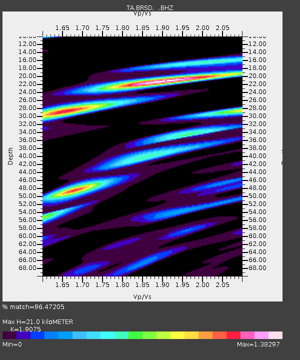
| Estimated Moho Depth: |
21.0 km |
| Estimated Crust Vp/Vs: |
1.91 |
| Assumed Crust Vp: |
6.53 km/s |
| Estimated Crust Vs: |
3.424 km/s |
| Estimated Crust Poisson's Ratio: |
0.31 |
|
| Radial Match: |
96.47205 % |
| Radial Bump: |
400 |
| Transverse Match: |
93.68099 % |
| Transverse Bump: |
400 |
| SOD ConfigId: |
2658 |
| Insert Time: |
2010-03-06 19:28:57.504 +0000 |
| GWidth: |
2.5 |
| Max Bumps: |
400 |
| Tol: |
0.001 |
|
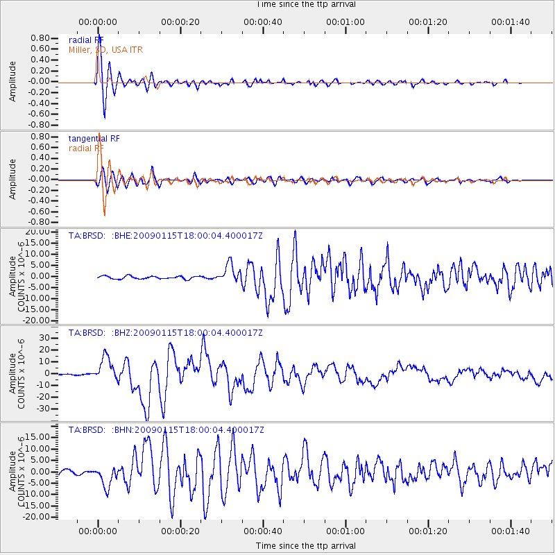
Signal To Noise
| Channel | StoN | STA | LTA |
| TA:BRSD: :BHZ:20090115T18:00:04.400017Z | 31.347486 | 1.0592186E-5 | 3.3789587E-7 |
| TA:BRSD: :BHN:20090115T18:00:04.400017Z | 4.2594075 | 4.7027934E-6 | 1.1040956E-6 |
| TA:BRSD: :BHE:20090115T18:00:04.400017Z | 6.641246 | 4.2677457E-6 | 6.426122E-7 |
| Arrivals |
| Ps | 3.0 SECOND |
| PpPs | 9.0 SECOND |
| PsPs/PpSs | 12 SECOND |


