You are here: Home > Network List > TA - USArray Transportable Network (new EarthScope stations) Stations List
> Station BRSD Miller, SD, USA > Earthquake Result Viewer
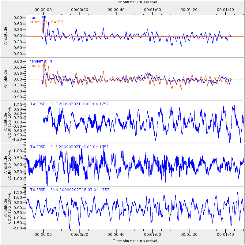
BRSD Miller, SD, USA - Earthquake Result Viewer
*The percent match for this event was below the threshold and hence no stack was calculated.
| Earthquake location: |
Near Coast Of Peru |
| Earthquake latitude/longitude: |
-13.6/-76.6 |
| Earthquake time(UTC): |
2009/02/02 (033) 17:53:21 GMT |
| Earthquake Depth: |
21 km |
| Earthquake Magnitude: |
5.6 MB, 5.6 MS, 6.0 MW, 5.9 MW |
| Earthquake Catalog/Contributor: |
WHDF/NEIC |
|
| Network: |
TA USArray Transportable Network (new EarthScope stations) |
| Station: |
BRSD Miller, SD, USA |
| Lat/Lon: |
44.44 N/98.96 W |
| Elevation: |
519 m |
|
| Distance: |
61.2 deg |
| Az: |
341.86 deg |
| Baz: |
154.997 deg |
| Ray Param: |
$rayparam |
*The percent match for this event was below the threshold and hence was not used in the summary stack. |
|
| Radial Match: |
66.99102 % |
| Radial Bump: |
400 |
| Transverse Match: |
59.716293 % |
| Transverse Bump: |
400 |
| SOD ConfigId: |
6627 |
| Insert Time: |
2010-03-06 19:29:12.417 +0000 |
| GWidth: |
2.5 |
| Max Bumps: |
400 |
| Tol: |
0.001 |
|
Signal To Noise
| Channel | StoN | STA | LTA |
| TA:BRSD: :BHZ:20090202T18:03:04.175Z | 1.1454151 | 5.2387935E-7 | 4.5737076E-7 |
| TA:BRSD: :BHN:20090202T18:03:04.175Z | 0.8747506 | 5.682E-7 | 6.495565E-7 |
| TA:BRSD: :BHE:20090202T18:03:04.175Z | 0.9394679 | 3.9293766E-7 | 4.1825552E-7 |
| Arrivals |
| Ps | |
| PpPs | |
| PsPs/PpSs | |


