You are here: Home > Network List > TA - USArray Transportable Network (new EarthScope stations) Stations List
> Station BRSD Miller, SD, USA > Earthquake Result Viewer
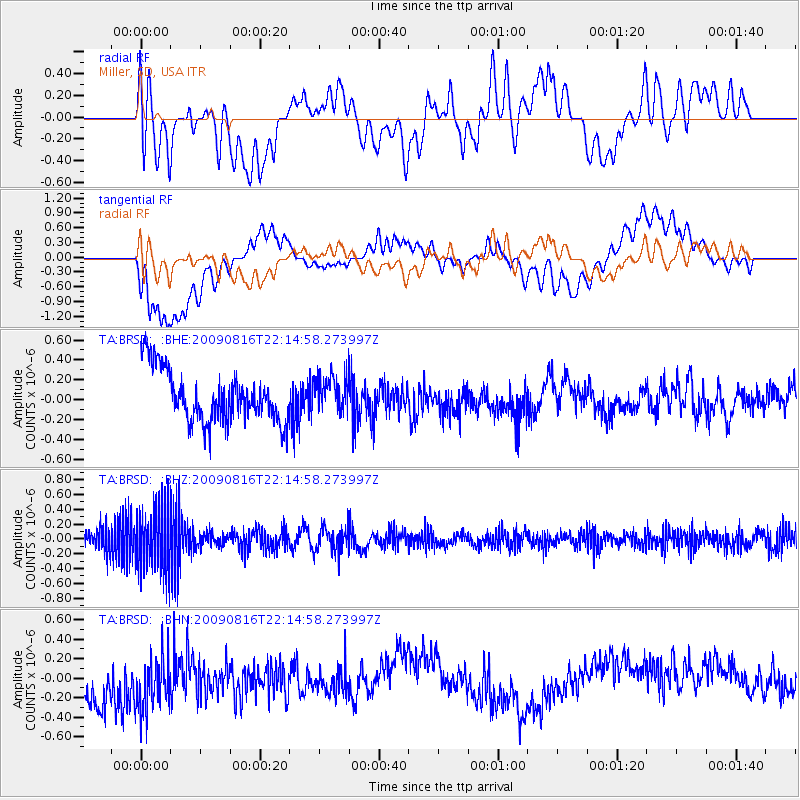
BRSD Miller, SD, USA - Earthquake Result Viewer
*The percent match for this event was below the threshold and hence no stack was calculated.
| Earthquake location: |
Fiji Islands Region |
| Earthquake latitude/longitude: |
-17.9/-179.4 |
| Earthquake time(UTC): |
2009/08/16 (228) 22:03:09 GMT |
| Earthquake Depth: |
626 km |
| Earthquake Magnitude: |
5.5 MW, 4.9 MB |
| Earthquake Catalog/Contributor: |
WHDF/NEIC |
|
| Network: |
TA USArray Transportable Network (new EarthScope stations) |
| Station: |
BRSD Miller, SD, USA |
| Lat/Lon: |
44.44 N/98.96 W |
| Elevation: |
519 m |
|
| Distance: |
95.8 deg |
| Az: |
45.23 deg |
| Baz: |
250.657 deg |
| Ray Param: |
$rayparam |
*The percent match for this event was below the threshold and hence was not used in the summary stack. |
|
| Radial Match: |
45.599186 % |
| Radial Bump: |
400 |
| Transverse Match: |
49.55473 % |
| Transverse Bump: |
400 |
| SOD ConfigId: |
2622 |
| Insert Time: |
2010-03-06 19:29:14.540 +0000 |
| GWidth: |
2.5 |
| Max Bumps: |
400 |
| Tol: |
0.001 |
|
Signal To Noise
| Channel | StoN | STA | LTA |
| TA:BRSD: :BHZ:20090816T22:14:58.273997Z | 2.6147149 | 4.2561527E-7 | 1.6277694E-7 |
| TA:BRSD: :BHN:20090816T22:14:58.273997Z | 1.0539168 | 3.2742798E-7 | 3.1067725E-7 |
| TA:BRSD: :BHE:20090816T22:14:58.273997Z | 0.6786762 | 1.7800068E-7 | 2.622763E-7 |
| Arrivals |
| Ps | |
| PpPs | |
| PsPs/PpSs | |


