You are here: Home > Network List > TA - USArray Transportable Network (new EarthScope stations) Stations List
> Station BRSD Miller, SD, USA > Earthquake Result Viewer
BRSD Miller, SD, USA - Earthquake Result Viewer
*The percent match for this event was below the threshold and hence no stack was calculated.
| Earthquake location: |
Rat Islands, Aleutian Islands |
| Earthquake latitude/longitude: |
52.2/178.1 |
| Earthquake time(UTC): |
2009/10/07 (280) 05:38:37 GMT |
| Earthquake Depth: |
138 km |
| Earthquake Magnitude: |
5.6 MB, 5.6 MW, 5.6 MW |
| Earthquake Catalog/Contributor: |
WHDF/NEIC |
|
| Network: |
TA USArray Transportable Network (new EarthScope stations) |
| Station: |
BRSD Miller, SD, USA |
| Lat/Lon: |
44.44 N/98.96 W |
| Elevation: |
519 m |
|
| Distance: |
52.9 deg |
| Az: |
63.076 deg |
| Baz: |
309.928 deg |
| Ray Param: |
$rayparam |
*The percent match for this event was below the threshold and hence was not used in the summary stack. |
|
| Radial Match: |
60.499016 % |
| Radial Bump: |
400 |
| Transverse Match: |
50.505024 % |
| Transverse Bump: |
400 |
| SOD ConfigId: |
2622 |
| Insert Time: |
2010-03-06 19:29:26.355 +0000 |
| GWidth: |
2.5 |
| Max Bumps: |
400 |
| Tol: |
0.001 |
|
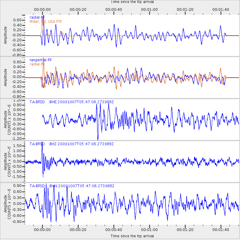
Signal To Noise
| Channel | StoN | STA | LTA |
| TA:BRSD: :BHZ:20091007T05:47:08.273988Z | 5.8882895 | 6.795912E-7 | 1.1541403E-7 |
| TA:BRSD: :BHN:20091007T05:47:08.273988Z | 2.830963 | 4.7534104E-7 | 1.679079E-7 |
| TA:BRSD: :BHE:20091007T05:47:08.273988Z | 2.6829748 | 5.667544E-7 | 2.1124103E-7 |
| Arrivals |
| Ps | |
| PpPs | |
| PsPs/PpSs | |


