You are here: Home > Network List > TA - USArray Transportable Network (new EarthScope stations) Stations List
> Station BRSD Miller, SD, USA > Earthquake Result Viewer
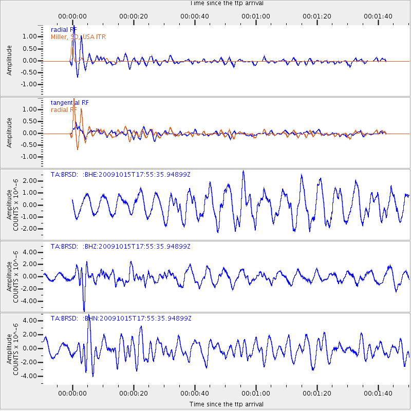
BRSD Miller, SD, USA - Earthquake Result Viewer
*The percent match for this event was below the threshold and hence no stack was calculated.
| Earthquake location: |
Galapagos Triple Junction Region |
| Earthquake latitude/longitude: |
3.3/-103.8 |
| Earthquake time(UTC): |
2009/10/15 (288) 17:48:21 GMT |
| Earthquake Depth: |
10 km |
| Earthquake Magnitude: |
5.9 MB, 5.7 MS, 6.0 MW, 6.0 MW |
| Earthquake Catalog/Contributor: |
WHDF/NEIC |
|
| Network: |
TA USArray Transportable Network (new EarthScope stations) |
| Station: |
BRSD Miller, SD, USA |
| Lat/Lon: |
44.44 N/98.96 W |
| Elevation: |
519 m |
|
| Distance: |
41.2 deg |
| Az: |
5.291 deg |
| Baz: |
187.384 deg |
| Ray Param: |
$rayparam |
*The percent match for this event was below the threshold and hence was not used in the summary stack. |
|
| Radial Match: |
68.77436 % |
| Radial Bump: |
400 |
| Transverse Match: |
78.14013 % |
| Transverse Bump: |
400 |
| SOD ConfigId: |
2622 |
| Insert Time: |
2010-03-06 19:29:27.555 +0000 |
| GWidth: |
2.5 |
| Max Bumps: |
400 |
| Tol: |
0.001 |
|
Signal To Noise
| Channel | StoN | STA | LTA |
| TA:BRSD: :BHZ:20091015T17:55:35.94899Z | 3.4760697 | 1.9299023E-6 | 5.5519666E-7 |
| TA:BRSD: :BHN:20091015T17:55:35.94899Z | 1.7413967 | 1.1881514E-6 | 6.82298E-7 |
| TA:BRSD: :BHE:20091015T17:55:35.94899Z | 1.3047026 | 8.711463E-7 | 6.6769724E-7 |
| Arrivals |
| Ps | |
| PpPs | |
| PsPs/PpSs | |


