You are here: Home > Network List > TA - USArray Transportable Network (new EarthScope stations) Stations List
> Station 121A Cookes Peak, Deming, NM, USA > Earthquake Result Viewer
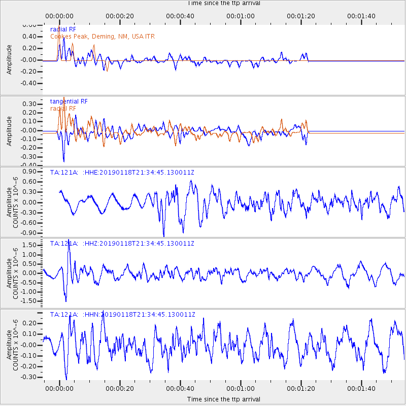
121A Cookes Peak, Deming, NM, USA - Earthquake Result Viewer
*The percent match for this event was below the threshold and hence no stack was calculated.
| Earthquake location: |
Northern Peru |
| Earthquake latitude/longitude: |
-3.3/-76.9 |
| Earthquake time(UTC): |
2019/01/18 (018) 21:27:01 GMT |
| Earthquake Depth: |
103 km |
| Earthquake Magnitude: |
5.7 Mww |
| Earthquake Catalog/Contributor: |
NEIC PDE/us |
|
| Network: |
TA USArray Transportable Network (new EarthScope stations) |
| Station: |
121A Cookes Peak, Deming, NM, USA |
| Lat/Lon: |
32.53 N/107.79 W |
| Elevation: |
1652 m |
|
| Distance: |
46.2 deg |
| Az: |
322.98 deg |
| Baz: |
134.634 deg |
| Ray Param: |
$rayparam |
*The percent match for this event was below the threshold and hence was not used in the summary stack. |
|
| Radial Match: |
60.207687 % |
| Radial Bump: |
380 |
| Transverse Match: |
56.794537 % |
| Transverse Bump: |
400 |
| SOD ConfigId: |
13570011 |
| Insert Time: |
2019-05-02 08:20:07.032 +0000 |
| GWidth: |
2.5 |
| Max Bumps: |
400 |
| Tol: |
0.001 |
|
Signal To Noise
| Channel | StoN | STA | LTA |
| TA:121A: :HHZ:20190118T21:34:45.130011Z | 3.1559236 | 7.6167134E-7 | 2.4134658E-7 |
| TA:121A: :HHN:20190118T21:34:45.130011Z | 1.5297983 | 1.5645969E-7 | 1.02274726E-7 |
| TA:121A: :HHE:20190118T21:34:45.130011Z | 1.9895562 | 3.5050638E-7 | 1.7617316E-7 |
| Arrivals |
| Ps | |
| PpPs | |
| PsPs/PpSs | |


