You are here: Home > Network List > TA - USArray Transportable Network (new EarthScope stations) Stations List
> Station C16K Lisburne Hills, AK, USA > Earthquake Result Viewer
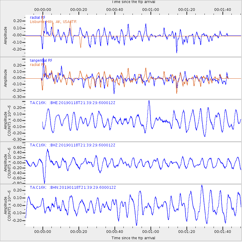
C16K Lisburne Hills, AK, USA - Earthquake Result Viewer
*The percent match for this event was below the threshold and hence no stack was calculated.
| Earthquake location: |
Northern Peru |
| Earthquake latitude/longitude: |
-3.3/-76.9 |
| Earthquake time(UTC): |
2019/01/18 (018) 21:27:01 GMT |
| Earthquake Depth: |
103 km |
| Earthquake Magnitude: |
5.7 Mww |
| Earthquake Catalog/Contributor: |
NEIC PDE/us |
|
| Network: |
TA USArray Transportable Network (new EarthScope stations) |
| Station: |
C16K Lisburne Hills, AK, USA |
| Lat/Lon: |
68.27 N/165.34 W |
| Elevation: |
102 m |
|
| Distance: |
92.5 deg |
| Az: |
338.128 deg |
| Baz: |
92.622 deg |
| Ray Param: |
$rayparam |
*The percent match for this event was below the threshold and hence was not used in the summary stack. |
|
| Radial Match: |
65.916695 % |
| Radial Bump: |
389 |
| Transverse Match: |
60.94342 % |
| Transverse Bump: |
400 |
| SOD ConfigId: |
13570011 |
| Insert Time: |
2019-05-02 08:20:13.259 +0000 |
| GWidth: |
2.5 |
| Max Bumps: |
400 |
| Tol: |
0.001 |
|
Signal To Noise
| Channel | StoN | STA | LTA |
| TA:C16K: :BHZ:20190118T21:39:29.600012Z | 4.237493 | 3.723135E-7 | 8.7861736E-8 |
| TA:C16K: :BHN:20190118T21:39:29.600012Z | 0.66350925 | 5.49348E-8 | 8.279433E-8 |
| TA:C16K: :BHE:20190118T21:39:29.600012Z | 0.99745744 | 9.294555E-8 | 9.3182464E-8 |
| Arrivals |
| Ps | |
| PpPs | |
| PsPs/PpSs | |


