You are here: Home > Network List > TA - USArray Transportable Network (new EarthScope stations) Stations List
> Station BRSD Miller, SD, USA > Earthquake Result Viewer
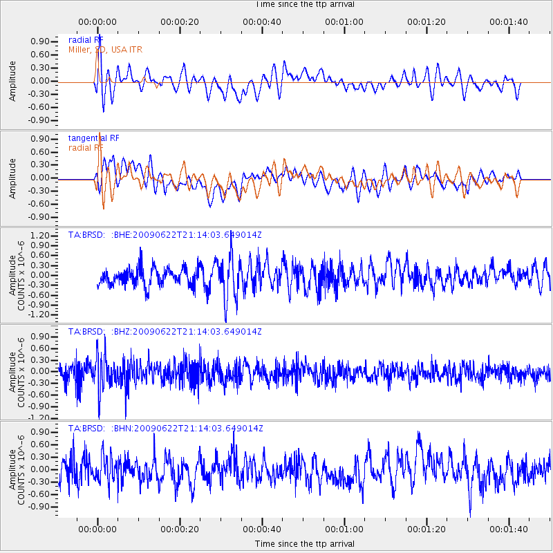
BRSD Miller, SD, USA - Earthquake Result Viewer
*The percent match for this event was below the threshold and hence no stack was calculated.
| Earthquake location: |
Andreanof Islands, Aleutian Is. |
| Earthquake latitude/longitude: |
51.3/-178.2 |
| Earthquake time(UTC): |
2009/06/22 (173) 21:05:33 GMT |
| Earthquake Depth: |
29 km |
| Earthquake Magnitude: |
5.5 MB, 5.0 MS, 5.4 MW, 5.4 MW |
| Earthquake Catalog/Contributor: |
WHDF/NEIC |
|
| Network: |
TA USArray Transportable Network (new EarthScope stations) |
| Station: |
BRSD Miller, SD, USA |
| Lat/Lon: |
44.44 N/98.96 W |
| Elevation: |
519 m |
|
| Distance: |
51.2 deg |
| Az: |
64.615 deg |
| Baz: |
307.717 deg |
| Ray Param: |
$rayparam |
*The percent match for this event was below the threshold and hence was not used in the summary stack. |
|
| Radial Match: |
62.533768 % |
| Radial Bump: |
400 |
| Transverse Match: |
64.13728 % |
| Transverse Bump: |
400 |
| SOD ConfigId: |
2648 |
| Insert Time: |
2010-03-06 19:29:41.357 +0000 |
| GWidth: |
2.5 |
| Max Bumps: |
400 |
| Tol: |
0.001 |
|
Signal To Noise
| Channel | StoN | STA | LTA |
| TA:BRSD: :BHZ:20090622T21:14:03.649014Z | 2.1115272 | 4.5555404E-7 | 2.1574623E-7 |
| TA:BRSD: :BHN:20090622T21:14:03.649014Z | 1.3141788 | 3.147799E-7 | 2.3952592E-7 |
| TA:BRSD: :BHE:20090622T21:14:03.649014Z | 2.5118816 | 6.4897506E-7 | 2.5836212E-7 |
| Arrivals |
| Ps | |
| PpPs | |
| PsPs/PpSs | |


