You are here: Home > Network List > TA - USArray Transportable Network (new EarthScope stations) Stations List
> Station F26K Sheenjek River, AK, USA > Earthquake Result Viewer
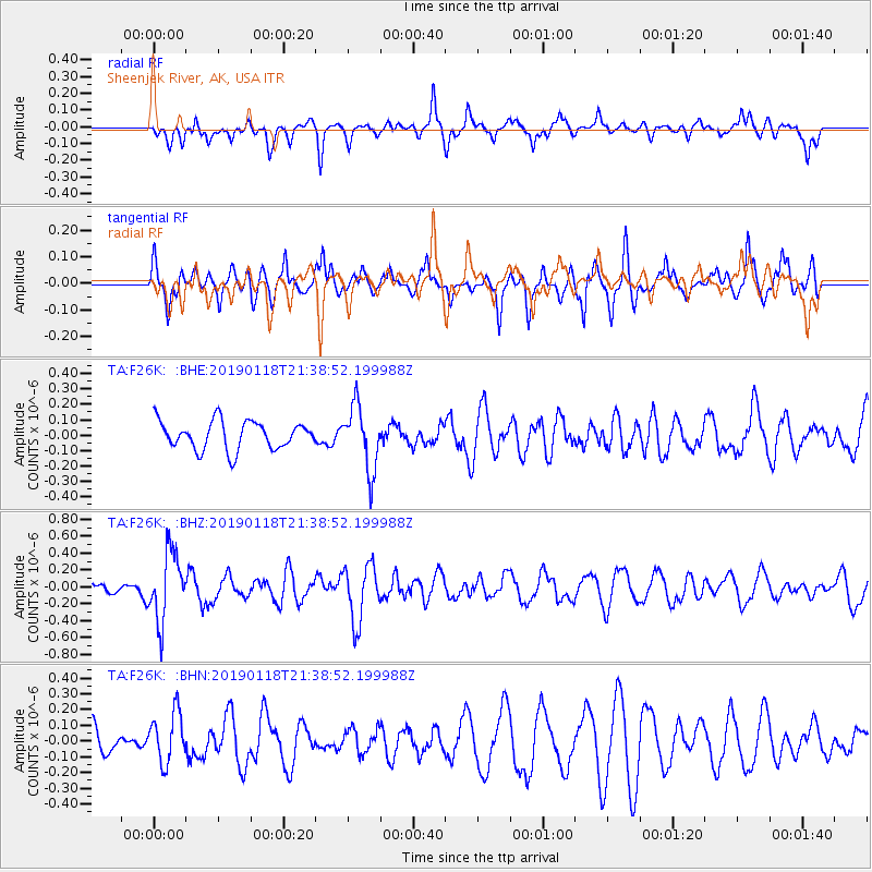
F26K Sheenjek River, AK, USA - Earthquake Result Viewer
*The percent match for this event was below the threshold and hence no stack was calculated.
| Earthquake location: |
Northern Peru |
| Earthquake latitude/longitude: |
-3.3/-76.9 |
| Earthquake time(UTC): |
2019/01/18 (018) 21:27:01 GMT |
| Earthquake Depth: |
103 km |
| Earthquake Magnitude: |
5.7 Mww |
| Earthquake Catalog/Contributor: |
NEIC PDE/us |
|
| Network: |
TA USArray Transportable Network (new EarthScope stations) |
| Station: |
F26K Sheenjek River, AK, USA |
| Lat/Lon: |
67.69 N/144.15 W |
| Elevation: |
683 m |
|
| Distance: |
84.6 deg |
| Az: |
339.285 deg |
| Baz: |
112.317 deg |
| Ray Param: |
$rayparam |
*The percent match for this event was below the threshold and hence was not used in the summary stack. |
|
| Radial Match: |
62.965725 % |
| Radial Bump: |
390 |
| Transverse Match: |
70.24361 % |
| Transverse Bump: |
386 |
| SOD ConfigId: |
13570011 |
| Insert Time: |
2019-05-02 08:20:38.170 +0000 |
| GWidth: |
2.5 |
| Max Bumps: |
400 |
| Tol: |
0.001 |
|
Signal To Noise
| Channel | StoN | STA | LTA |
| TA:F26K: :BHZ:20190118T21:38:52.199988Z | 2.280033 | 4.069287E-7 | 1.784749E-7 |
| TA:F26K: :BHN:20190118T21:38:52.199988Z | 1.4813828 | 1.5960508E-7 | 1.07740604E-7 |
| TA:F26K: :BHE:20190118T21:38:52.199988Z | 2.2592132 | 2.0621682E-7 | 9.127815E-8 |
| Arrivals |
| Ps | |
| PpPs | |
| PsPs/PpSs | |


