You are here: Home > Network List > TA - USArray Transportable Network (new EarthScope stations) Stations List
> Station BRSD Miller, SD, USA > Earthquake Result Viewer
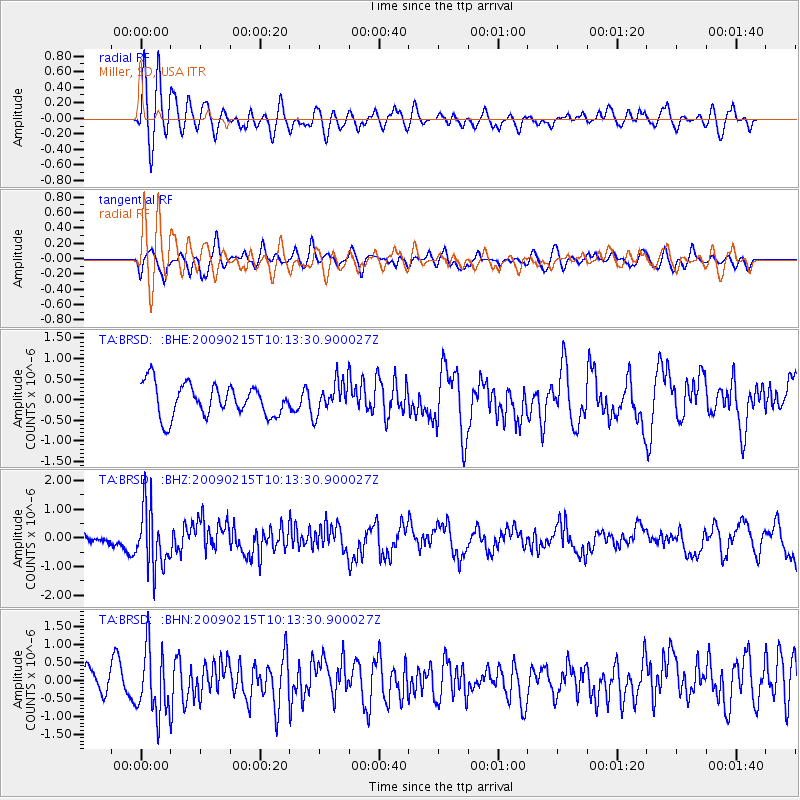
BRSD Miller, SD, USA - Earthquake Result Viewer
*The percent match for this event was below the threshold and hence no stack was calculated.
| Earthquake location: |
Near Coast Of Northern Peru |
| Earthquake latitude/longitude: |
-5.9/-80.9 |
| Earthquake time(UTC): |
2009/02/15 (046) 10:04:49 GMT |
| Earthquake Depth: |
21 km |
| Earthquake Magnitude: |
5.8 MB, 5.7 MS, 6.1 MW, 6.1 MW |
| Earthquake Catalog/Contributor: |
WHDF/NEIC |
|
| Network: |
TA USArray Transportable Network (new EarthScope stations) |
| Station: |
BRSD Miller, SD, USA |
| Lat/Lon: |
44.44 N/98.96 W |
| Elevation: |
519 m |
|
| Distance: |
52.6 deg |
| Az: |
343.773 deg |
| Baz: |
157.162 deg |
| Ray Param: |
$rayparam |
*The percent match for this event was below the threshold and hence was not used in the summary stack. |
|
| Radial Match: |
69.73191 % |
| Radial Bump: |
400 |
| Transverse Match: |
59.926674 % |
| Transverse Bump: |
400 |
| SOD ConfigId: |
2658 |
| Insert Time: |
2010-03-06 19:29:55.345 +0000 |
| GWidth: |
2.5 |
| Max Bumps: |
400 |
| Tol: |
0.001 |
|
Signal To Noise
| Channel | StoN | STA | LTA |
| TA:BRSD: :BHZ:20090215T10:13:30.900027Z | 2.9202878 | 1.0549353E-6 | 3.612436E-7 |
| TA:BRSD: :BHN:20090215T10:13:30.900027Z | 2.8845263 | 9.1700923E-7 | 3.1790634E-7 |
| TA:BRSD: :BHE:20090215T10:13:30.900027Z | 1.0094849 | 3.9249096E-7 | 3.8880324E-7 |
| Arrivals |
| Ps | |
| PpPs | |
| PsPs/PpSs | |


