You are here: Home > Network List > TA - USArray Transportable Network (new EarthScope stations) Stations List
> Station I30M Mount Dempster, Yukon, CAN > Earthquake Result Viewer
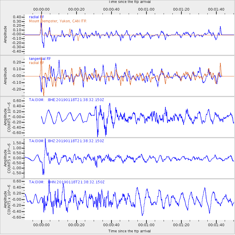
I30M Mount Dempster, Yukon, CAN - Earthquake Result Viewer
*The percent match for this event was below the threshold and hence no stack was calculated.
| Earthquake location: |
Northern Peru |
| Earthquake latitude/longitude: |
-3.3/-76.9 |
| Earthquake time(UTC): |
2019/01/18 (018) 21:27:01 GMT |
| Earthquake Depth: |
103 km |
| Earthquake Magnitude: |
5.7 Mww |
| Earthquake Catalog/Contributor: |
NEIC PDE/us |
|
| Network: |
TA USArray Transportable Network (new EarthScope stations) |
| Station: |
I30M Mount Dempster, Yukon, CAN |
| Lat/Lon: |
65.22 N/136.38 W |
| Elevation: |
1399 m |
|
| Distance: |
80.7 deg |
| Az: |
338.406 deg |
| Baz: |
119.322 deg |
| Ray Param: |
$rayparam |
*The percent match for this event was below the threshold and hence was not used in the summary stack. |
|
| Radial Match: |
68.70842 % |
| Radial Bump: |
400 |
| Transverse Match: |
50.764378 % |
| Transverse Bump: |
400 |
| SOD ConfigId: |
13570011 |
| Insert Time: |
2019-05-02 08:21:02.108 +0000 |
| GWidth: |
2.5 |
| Max Bumps: |
400 |
| Tol: |
0.001 |
|
Signal To Noise
| Channel | StoN | STA | LTA |
| TA:I30M: :BHZ:20190118T21:38:32.150Z | 6.3006477 | 8.2697096E-7 | 1.3125174E-7 |
| TA:I30M: :BHN:20190118T21:38:32.150Z | 1.4843752 | 2.1923167E-7 | 1.4769289E-7 |
| TA:I30M: :BHE:20190118T21:38:32.150Z | 2.0629652 | 2.8673682E-7 | 1.3899255E-7 |
| Arrivals |
| Ps | |
| PpPs | |
| PsPs/PpSs | |


