You are here: Home > Network List > TA - USArray Transportable Network (new EarthScope stations) Stations List
> Station J26L Joseph Creek, AK, USA > Earthquake Result Viewer
J26L Joseph Creek, AK, USA - Earthquake Result Viewer
*The percent match for this event was below the threshold and hence no stack was calculated.
| Earthquake location: |
Northern Peru |
| Earthquake latitude/longitude: |
-3.3/-76.9 |
| Earthquake time(UTC): |
2019/01/18 (018) 21:27:01 GMT |
| Earthquake Depth: |
103 km |
| Earthquake Magnitude: |
5.7 Mww |
| Earthquake Catalog/Contributor: |
NEIC PDE/us |
|
| Network: |
TA USArray Transportable Network (new EarthScope stations) |
| Station: |
J26L Joseph Creek, AK, USA |
| Lat/Lon: |
64.50 N/143.56 W |
| Elevation: |
1144 m |
|
| Distance: |
83.2 deg |
| Az: |
336.394 deg |
| Baz: |
112.54 deg |
| Ray Param: |
$rayparam |
*The percent match for this event was below the threshold and hence was not used in the summary stack. |
|
| Radial Match: |
42.989532 % |
| Radial Bump: |
305 |
| Transverse Match: |
61.444885 % |
| Transverse Bump: |
391 |
| SOD ConfigId: |
13570011 |
| Insert Time: |
2019-05-02 08:21:07.439 +0000 |
| GWidth: |
2.5 |
| Max Bumps: |
400 |
| Tol: |
0.001 |
|
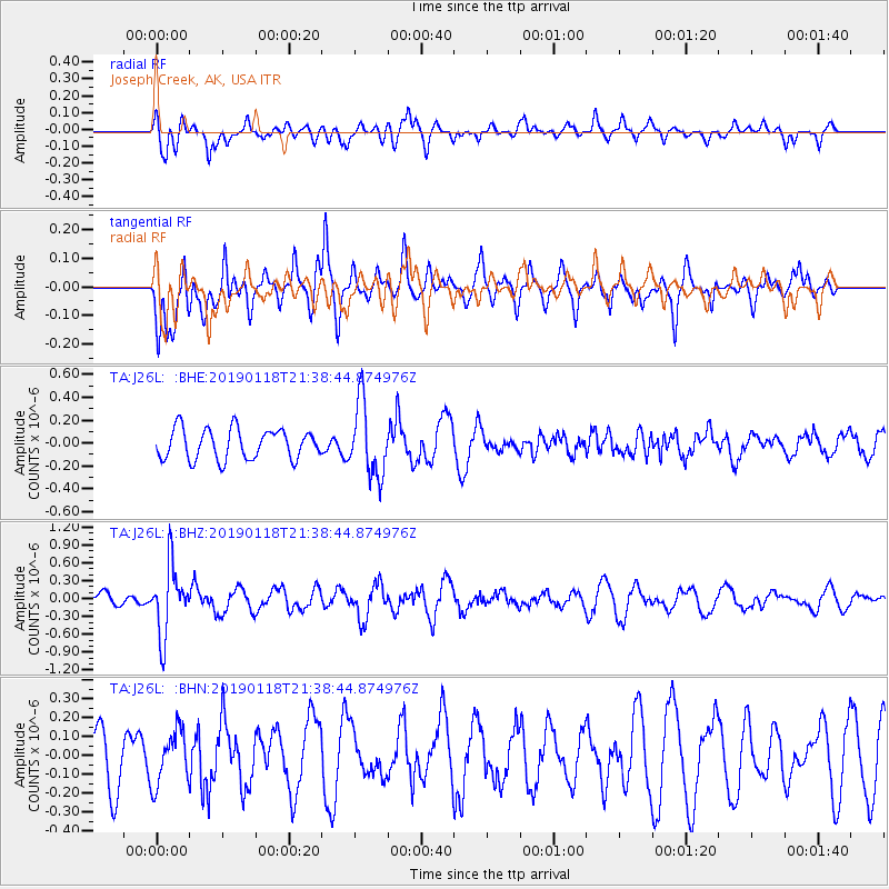
Signal To Noise
| Channel | StoN | STA | LTA |
| TA:J26L: :BHZ:20190118T21:38:44.874976Z | 6.273544 | 5.7494896E-7 | 9.1646605E-8 |
| TA:J26L: :BHN:20190118T21:38:44.874976Z | 1.1537411 | 1.4015558E-7 | 1.2147923E-7 |
| TA:J26L: :BHE:20190118T21:38:44.874976Z | 2.4285002 | 3.2049164E-7 | 1.3197102E-7 |
| Arrivals |
| Ps | |
| PpPs | |
| PsPs/PpSs | |


