You are here: Home > Network List > TA - USArray Transportable Network (new EarthScope stations) Stations List
> Station M25A Palm-Egli Farm, Albin, WY, USA > Earthquake Result Viewer
M25A Palm-Egli Farm, Albin, WY, USA - Earthquake Result Viewer
| Earthquake location: |
Kodiak Island Region, Alaska |
| Earthquake latitude/longitude: |
56.5/-152.7 |
| Earthquake time(UTC): |
2009/03/30 (089) 07:13:07 GMT |
| Earthquake Depth: |
21 km |
| Earthquake Magnitude: |
5.9 MB, 5.9 MS, 5.9 MW, 5.9 MW |
| Earthquake Catalog/Contributor: |
WHDF/NEIC |
|
| Network: |
TA USArray Transportable Network (new EarthScope stations) |
| Station: |
M25A Palm-Egli Farm, Albin, WY, USA |
| Lat/Lon: |
41.43 N/104.06 W |
| Elevation: |
1636 m |
|
| Distance: |
34.5 deg |
| Az: |
94.875 deg |
| Baz: |
312.784 deg |
| Ray Param: |
0.07766811 |
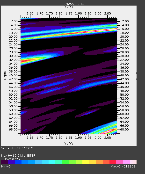
| Estimated Moho Depth: |
16.0 km |
| Estimated Crust Vp/Vs: |
2.07 |
| Assumed Crust Vp: |
6.306 km/s |
| Estimated Crust Vs: |
3.043 km/s |
| Estimated Crust Poisson's Ratio: |
0.35 |
|
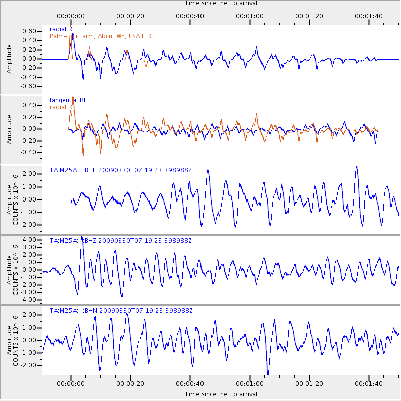
| Radial Match: |
87.643715 % |
| Radial Bump: |
400 |
| Transverse Match: |
74.65416 % |
| Transverse Bump: |
400 |
| SOD ConfigId: |
2658 |
| Insert Time: |
2010-03-06 19:30:27.607 +0000 |
| GWidth: |
2.5 |
| Max Bumps: |
400 |
| Tol: |
0.001 |
|
Signal To Noise
| Channel | StoN | STA | LTA |
| TA:M25A: :BHZ:20090330T07:19:23.398988Z | 7.459764 | 2.0871632E-6 | 2.7978945E-7 |
| TA:M25A: :BHN:20090330T07:19:23.398988Z | 1.3814926 | 7.6612116E-7 | 5.545604E-7 |
| TA:M25A: :BHE:20090330T07:19:23.398988Z | 1.7637491 | 7.5325545E-7 | 4.270763E-7 |
| Arrivals |
| Ps | 2.9 SECOND |
| PpPs | 7.3 SECOND |
| PsPs/PpSs | 10 SECOND |


