You are here: Home > Network List > AZ - ANZA Regional Network Stations List
> Station TMSP TMSP, CA, USA > Earthquake Result Viewer
TMSP TMSP, CA, USA - Earthquake Result Viewer
| Earthquake location: |
Near Coast Of Central Chile |
| Earthquake latitude/longitude: |
-30.1/-71.4 |
| Earthquake time(UTC): |
2019/01/20 (020) 01:32:51 GMT |
| Earthquake Depth: |
53 km |
| Earthquake Magnitude: |
6.7 mww |
| Earthquake Catalog/Contributor: |
NEIC PDE/us |
|
| Network: |
AZ ANZA Regional Network |
| Station: |
TMSP TMSP, CA, USA |
| Lat/Lon: |
33.62 N/116.68 W |
| Elevation: |
2077 m |
|
| Distance: |
76.4 deg |
| Az: |
322.434 deg |
| Baz: |
140.703 deg |
| Ray Param: |
0.050889608 |
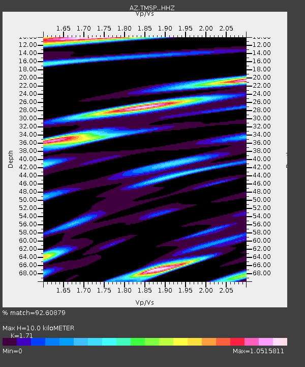
| Estimated Moho Depth: |
10.0 km |
| Estimated Crust Vp/Vs: |
1.71 |
| Assumed Crust Vp: |
6.264 km/s |
| Estimated Crust Vs: |
3.663 km/s |
| Estimated Crust Poisson's Ratio: |
0.24 |
|
| Radial Match: |
92.60879 % |
| Radial Bump: |
400 |
| Transverse Match: |
77.42358 % |
| Transverse Bump: |
400 |
| SOD ConfigId: |
13570011 |
| Insert Time: |
2019-05-02 08:25:00.368 +0000 |
| GWidth: |
2.5 |
| Max Bumps: |
400 |
| Tol: |
0.001 |
|

Signal To Noise
| Channel | StoN | STA | LTA |
| AZ:TMSP: :HHZ:20190120T01:44:04.693989Z | 22.161129 | 5.5408254E-6 | 2.500245E-7 |
| AZ:TMSP: :HHN:20190120T01:44:04.693989Z | 3.5666332 | 2.0897508E-6 | 5.859169E-7 |
| AZ:TMSP: :HHE:20190120T01:44:04.693989Z | 4.2907977 | 1.8256605E-6 | 4.2548277E-7 |
| Arrivals |
| Ps | 1.2 SECOND |
| PpPs | 4.2 SECOND |
| PsPs/PpSs | 5.4 SECOND |


