You are here: Home > Network List > TA - USArray Transportable Network (new EarthScope stations) Stations List
> Station M25A Palm-Egli Farm, Albin, WY, USA > Earthquake Result Viewer
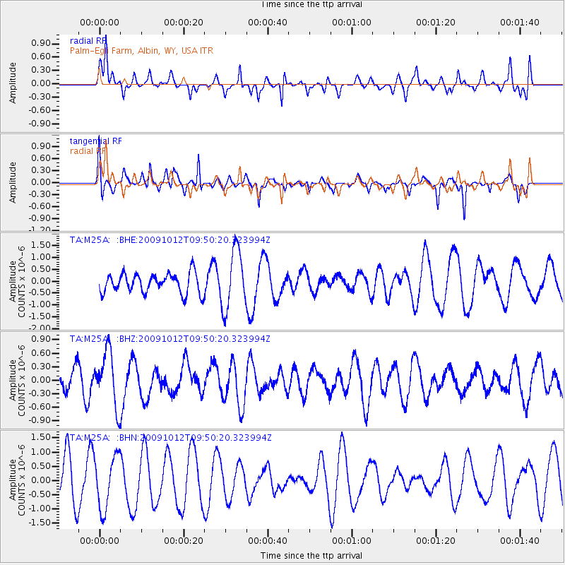
M25A Palm-Egli Farm, Albin, WY, USA - Earthquake Result Viewer
*The percent match for this event was below the threshold and hence no stack was calculated.
| Earthquake location: |
Santa Cruz Islands |
| Earthquake latitude/longitude: |
-12.4/166.5 |
| Earthquake time(UTC): |
2009/10/12 (285) 09:37:21 GMT |
| Earthquake Depth: |
42 km |
| Earthquake Magnitude: |
5.9 MB, 5.9 MS, 6.2 MW, 6.2 MW |
| Earthquake Catalog/Contributor: |
WHDF/NEIC |
|
| Network: |
TA USArray Transportable Network (new EarthScope stations) |
| Station: |
M25A Palm-Egli Farm, Albin, WY, USA |
| Lat/Lon: |
41.43 N/104.06 W |
| Elevation: |
1636 m |
|
| Distance: |
97.7 deg |
| Az: |
49.349 deg |
| Baz: |
260.309 deg |
| Ray Param: |
$rayparam |
*The percent match for this event was below the threshold and hence was not used in the summary stack. |
|
| Radial Match: |
66.44074 % |
| Radial Bump: |
400 |
| Transverse Match: |
70.11487 % |
| Transverse Bump: |
333 |
| SOD ConfigId: |
2622 |
| Insert Time: |
2010-03-06 19:30:54.550 +0000 |
| GWidth: |
2.5 |
| Max Bumps: |
400 |
| Tol: |
0.001 |
|
Signal To Noise
| Channel | StoN | STA | LTA |
| TA:M25A: :BHZ:20091012T09:50:20.323994Z | 2.9500737 | 6.208944E-7 | 2.1046742E-7 |
| TA:M25A: :BHN:20091012T09:50:20.323994Z | 1.1166463 | 9.2821006E-7 | 8.312481E-7 |
| TA:M25A: :BHE:20091012T09:50:20.323994Z | 3.0865324 | 1.2767887E-6 | 4.1366445E-7 |
| Arrivals |
| Ps | |
| PpPs | |
| PsPs/PpSs | |


