You are here: Home > Network List > TS - TERRAscope (Southern California Seismic Network) Stations List
> Station CALB Calabasas, California, USA > Earthquake Result Viewer
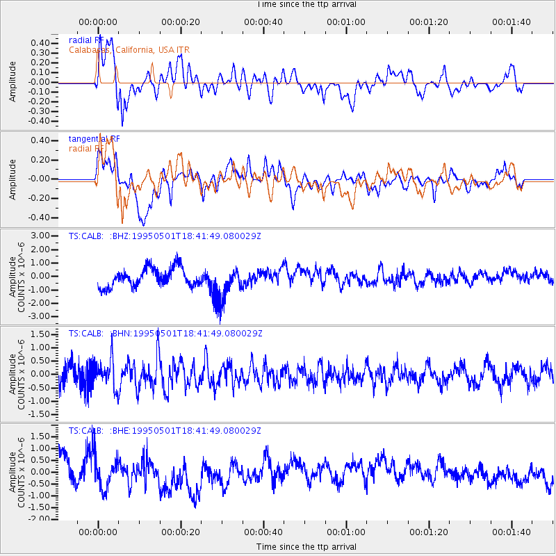
CALB Calabasas, California, USA - Earthquake Result Viewer
*The percent match for this event was below the threshold and hence no stack was calculated.
| Earthquake location: |
Solomon Islands |
| Earthquake latitude/longitude: |
-10.6/161.4 |
| Earthquake time(UTC): |
1995/05/01 (121) 18:29:41 GMT |
| Earthquake Depth: |
94 km |
| Earthquake Magnitude: |
5.5 MB, 6.0 UNKNOWN, 5.8 MW |
| Earthquake Catalog/Contributor: |
WHDF/NEIC |
|
| Network: |
TS TERRAscope (Southern California Seismic Network) |
| Station: |
CALB Calabasas, California, USA |
| Lat/Lon: |
34.14 N/118.63 W |
| Elevation: |
0.0 m |
|
| Distance: |
87.8 deg |
| Az: |
54.826 deg |
| Baz: |
255.662 deg |
| Ray Param: |
$rayparam |
*The percent match for this event was below the threshold and hence was not used in the summary stack. |
|
| Radial Match: |
31.528679 % |
| Radial Bump: |
400 |
| Transverse Match: |
52.201324 % |
| Transverse Bump: |
400 |
| SOD ConfigId: |
4480 |
| Insert Time: |
2010-02-26 14:03:55.523 +0000 |
| GWidth: |
2.5 |
| Max Bumps: |
400 |
| Tol: |
0.001 |
|
Signal To Noise
| Channel | StoN | STA | LTA |
| TS:CALB: :BHN:19950501T18:41:49.080029Z | 1.2941744 | 5.3176086E-7 | 4.1088805E-7 |
| TS:CALB: :BHE:19950501T18:41:49.080029Z | 1.8303815 | 7.5088013E-7 | 4.102315E-7 |
| TS:CALB: :BHZ:19950501T18:41:49.080029Z | 1.7728181 | 1.2192685E-6 | 6.877573E-7 |
| Arrivals |
| Ps | |
| PpPs | |
| PsPs/PpSs | |


