You are here: Home > Network List > TA - USArray Transportable Network (new EarthScope stations) Stations List
> Station M25A Palm-Egli Farm, Albin, WY, USA > Earthquake Result Viewer
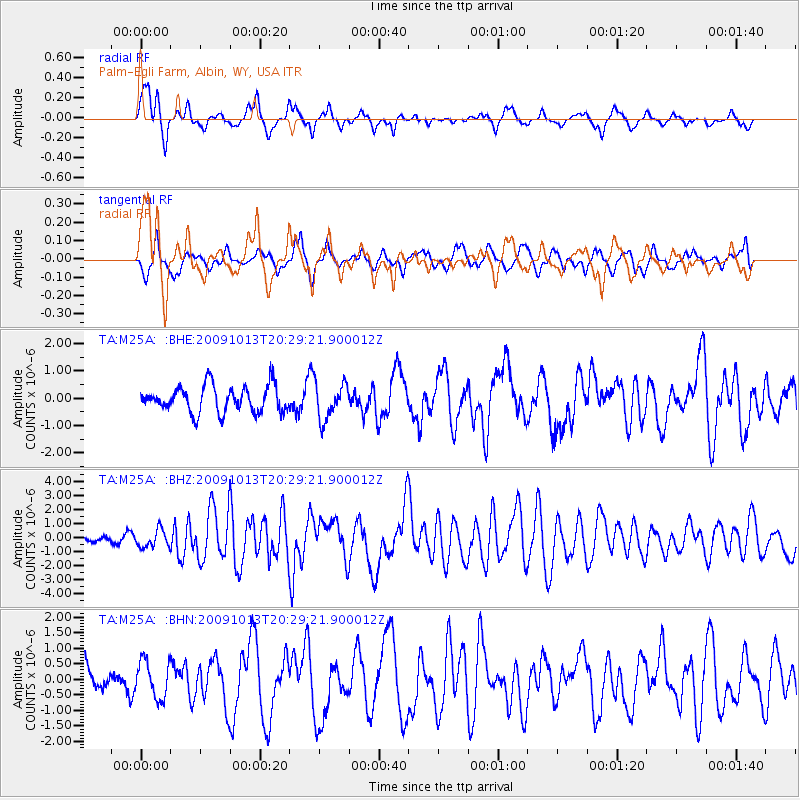
M25A Palm-Egli Farm, Albin, WY, USA - Earthquake Result Viewer
*The percent match for this event was below the threshold and hence no stack was calculated.
| Earthquake location: |
Fox Islands, Aleutian Islands |
| Earthquake latitude/longitude: |
52.6/-167.1 |
| Earthquake time(UTC): |
2009/10/13 (286) 20:21:53 GMT |
| Earthquake Depth: |
14 km |
| Earthquake Magnitude: |
5.9 MB, 6.4 MS, 6.4 MW, 6.4 MW |
| Earthquake Catalog/Contributor: |
WHDF/NEIC |
|
| Network: |
TA USArray Transportable Network (new EarthScope stations) |
| Station: |
M25A Palm-Egli Farm, Albin, WY, USA |
| Lat/Lon: |
41.43 N/104.06 W |
| Elevation: |
1636 m |
|
| Distance: |
43.1 deg |
| Az: |
78.848 deg |
| Baz: |
307.268 deg |
| Ray Param: |
$rayparam |
*The percent match for this event was below the threshold and hence was not used in the summary stack. |
|
| Radial Match: |
77.496735 % |
| Radial Bump: |
400 |
| Transverse Match: |
50.081627 % |
| Transverse Bump: |
390 |
| SOD ConfigId: |
2622 |
| Insert Time: |
2010-03-06 19:30:56.020 +0000 |
| GWidth: |
2.5 |
| Max Bumps: |
400 |
| Tol: |
0.001 |
|
Signal To Noise
| Channel | StoN | STA | LTA |
| TA:M25A: :BHZ:20091013T20:29:21.900012Z | 2.0184135 | 6.2660604E-7 | 3.1044482E-7 |
| TA:M25A: :BHN:20091013T20:29:21.900012Z | 1.0927898 | 5.9374275E-7 | 5.4332753E-7 |
| TA:M25A: :BHE:20091013T20:29:21.900012Z | 1.3555944 | 6.5795365E-7 | 4.8536174E-7 |
| Arrivals |
| Ps | |
| PpPs | |
| PsPs/PpSs | |


