You are here: Home > Network List > TA - USArray Transportable Network (new EarthScope stations) Stations List
> Station M25A Palm-Egli Farm, Albin, WY, USA > Earthquake Result Viewer
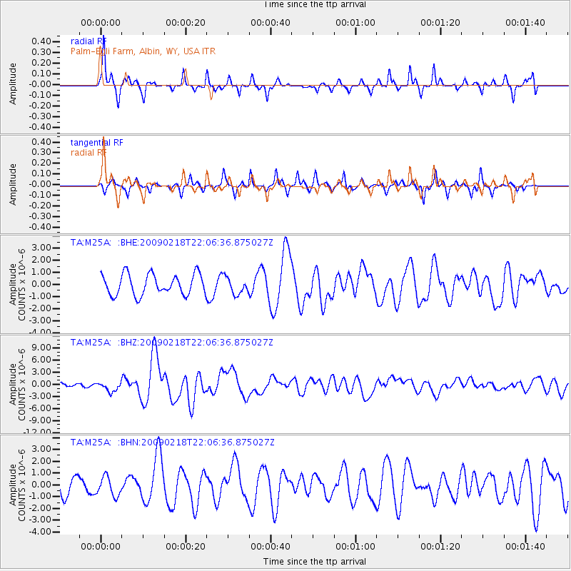
M25A Palm-Egli Farm, Albin, WY, USA - Earthquake Result Viewer
*The percent match for this event was below the threshold and hence no stack was calculated.
| Earthquake location: |
Kermadec Islands Region |
| Earthquake latitude/longitude: |
-27.4/-176.3 |
| Earthquake time(UTC): |
2009/02/18 (049) 21:53:45 GMT |
| Earthquake Depth: |
25 km |
| Earthquake Magnitude: |
6.8 MB, 7.2 MS, 6.9 MW, 6.9 MW |
| Earthquake Catalog/Contributor: |
WHDF/NEIC |
|
| Network: |
TA USArray Transportable Network (new EarthScope stations) |
| Station: |
M25A Palm-Egli Farm, Albin, WY, USA |
| Lat/Lon: |
41.43 N/104.06 W |
| Elevation: |
1636 m |
|
| Distance: |
95.7 deg |
| Az: |
46.031 deg |
| Baz: |
238.302 deg |
| Ray Param: |
$rayparam |
*The percent match for this event was below the threshold and hence was not used in the summary stack. |
|
| Radial Match: |
76.657715 % |
| Radial Bump: |
323 |
| Transverse Match: |
73.57199 % |
| Transverse Bump: |
239 |
| SOD ConfigId: |
2658 |
| Insert Time: |
2010-03-06 19:30:59.076 +0000 |
| GWidth: |
2.5 |
| Max Bumps: |
400 |
| Tol: |
0.001 |
|
Signal To Noise
| Channel | StoN | STA | LTA |
| TA:M25A: :BHZ:20090218T22:06:36.875027Z | 2.4812047 | 1.1974015E-6 | 4.8258875E-7 |
| TA:M25A: :BHN:20090218T22:06:36.875027Z | 1.2405136 | 8.1201614E-7 | 6.545806E-7 |
| TA:M25A: :BHE:20090218T22:06:36.875027Z | 0.79221 | 6.790666E-7 | 8.5718005E-7 |
| Arrivals |
| Ps | |
| PpPs | |
| PsPs/PpSs | |


