You are here: Home > Network List > TA - USArray Transportable Network (new EarthScope stations) Stations List
> Station K25A Mack Ranch, Harrison, NE, USA > Earthquake Result Viewer
K25A Mack Ranch, Harrison, NE, USA - Earthquake Result Viewer
| Earthquake location: |
Near Coast Of Venezuela |
| Earthquake latitude/longitude: |
10.7/-67.9 |
| Earthquake time(UTC): |
2009/09/12 (255) 20:06:24 GMT |
| Earthquake Depth: |
10 km |
| Earthquake Magnitude: |
6.3 MB, 6.4 MS, 6.3 MW, 6.3 MW |
| Earthquake Catalog/Contributor: |
WHDF/NEIC |
|
| Network: |
TA USArray Transportable Network (new EarthScope stations) |
| Station: |
K25A Mack Ranch, Harrison, NE, USA |
| Lat/Lon: |
42.61 N/103.87 W |
| Elevation: |
1437 m |
|
| Distance: |
44.6 deg |
| Az: |
321.898 deg |
| Baz: |
124.762 deg |
| Ray Param: |
0.071807034 |
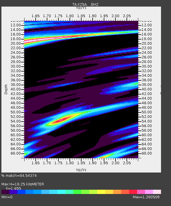
| Estimated Moho Depth: |
18.25 km |
| Estimated Crust Vp/Vs: |
1.65 |
| Assumed Crust Vp: |
6.483 km/s |
| Estimated Crust Vs: |
3.917 km/s |
| Estimated Crust Poisson's Ratio: |
0.21 |
|
| Radial Match: |
84.54374 % |
| Radial Bump: |
375 |
| Transverse Match: |
71.9418 % |
| Transverse Bump: |
400 |
| SOD ConfigId: |
2622 |
| Insert Time: |
2010-03-06 19:31:59.487 +0000 |
| GWidth: |
2.5 |
| Max Bumps: |
400 |
| Tol: |
0.001 |
|

Signal To Noise
| Channel | StoN | STA | LTA |
| TA:K25A: :BHZ:20090912T20:14:06.175005Z | 8.091761 | 1.4443101E-6 | 1.7849146E-7 |
| TA:K25A: :BHN:20090912T20:14:06.175005Z | 1.1041057 | 4.6593567E-7 | 4.2200276E-7 |
| TA:K25A: :BHE:20090912T20:14:06.175005Z | 1.3702762 | 6.7151973E-7 | 4.900616E-7 |
| Arrivals |
| Ps | 2.0 SECOND |
| PpPs | 7.0 SECOND |
| PsPs/PpSs | 8.9 SECOND |


