You are here: Home > Network List > TA - USArray Transportable Network (new EarthScope stations) Stations List
> Station K25A Mack Ranch, Harrison, NE, USA > Earthquake Result Viewer
K25A Mack Ranch, Harrison, NE, USA - Earthquake Result Viewer
| Earthquake location: |
Tonga Islands |
| Earthquake latitude/longitude: |
-16.3/-173.5 |
| Earthquake time(UTC): |
2009/10/02 (275) 01:07:39 GMT |
| Earthquake Depth: |
8.0 km |
| Earthquake Magnitude: |
6.1 MB, 6.0 MS, 6.1 MW, 6.1 MW |
| Earthquake Catalog/Contributor: |
WHDF/NEIC |
|
| Network: |
TA USArray Transportable Network (new EarthScope stations) |
| Station: |
K25A Mack Ranch, Harrison, NE, USA |
| Lat/Lon: |
42.61 N/103.87 W |
| Elevation: |
1437 m |
|
| Distance: |
86.6 deg |
| Az: |
43.877 deg |
| Baz: |
244.352 deg |
| Ray Param: |
0.0439043 |
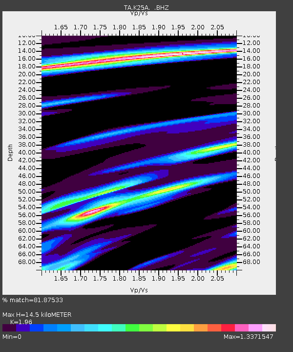
| Estimated Moho Depth: |
14.5 km |
| Estimated Crust Vp/Vs: |
1.96 |
| Assumed Crust Vp: |
6.483 km/s |
| Estimated Crust Vs: |
3.307 km/s |
| Estimated Crust Poisson's Ratio: |
0.32 |
|
| Radial Match: |
81.87533 % |
| Radial Bump: |
323 |
| Transverse Match: |
73.22452 % |
| Transverse Bump: |
400 |
| SOD ConfigId: |
2622 |
| Insert Time: |
2010-03-06 19:32:03.133 +0000 |
| GWidth: |
2.5 |
| Max Bumps: |
400 |
| Tol: |
0.001 |
|

Signal To Noise
| Channel | StoN | STA | LTA |
| TA:K25A: :BHZ:20091002T01:19:51.725027Z | 2.726309 | 5.637253E-7 | 2.0677233E-7 |
| TA:K25A: :BHN:20091002T01:19:51.725027Z | 1.6049207 | 2.3892486E-7 | 1.4887019E-7 |
| TA:K25A: :BHE:20091002T01:19:51.725027Z | 0.47469652 | 1.74707E-7 | 3.6803934E-7 |
| Arrivals |
| Ps | 2.2 SECOND |
| PpPs | 6.5 SECOND |
| PsPs/PpSs | 8.7 SECOND |


