You are here: Home > Network List > TA - USArray Transportable Network (new EarthScope stations) Stations List
> Station K25A Mack Ranch, Harrison, NE, USA > Earthquake Result Viewer
K25A Mack Ranch, Harrison, NE, USA - Earthquake Result Viewer
| Earthquake location: |
Kermadec Islands Region |
| Earthquake latitude/longitude: |
-27.4/-176.3 |
| Earthquake time(UTC): |
2009/02/18 (049) 21:53:45 GMT |
| Earthquake Depth: |
25 km |
| Earthquake Magnitude: |
6.8 MB, 7.2 MS, 6.9 MW, 6.9 MW |
| Earthquake Catalog/Contributor: |
WHDF/NEIC |
|
| Network: |
TA USArray Transportable Network (new EarthScope stations) |
| Station: |
K25A Mack Ranch, Harrison, NE, USA |
| Lat/Lon: |
42.61 N/103.87 W |
| Elevation: |
1437 m |
|
| Distance: |
96.4 deg |
| Az: |
45.096 deg |
| Baz: |
238.523 deg |
| Ray Param: |
0.04052024 |
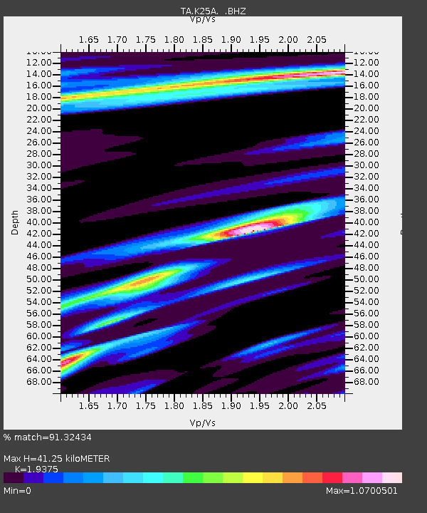
| Estimated Moho Depth: |
41.25 km |
| Estimated Crust Vp/Vs: |
1.94 |
| Assumed Crust Vp: |
6.483 km/s |
| Estimated Crust Vs: |
3.346 km/s |
| Estimated Crust Poisson's Ratio: |
0.32 |
|
| Radial Match: |
91.32434 % |
| Radial Bump: |
300 |
| Transverse Match: |
79.30159 % |
| Transverse Bump: |
400 |
| SOD ConfigId: |
2658 |
| Insert Time: |
2010-03-06 19:32:04.525 +0000 |
| GWidth: |
2.5 |
| Max Bumps: |
400 |
| Tol: |
0.001 |
|
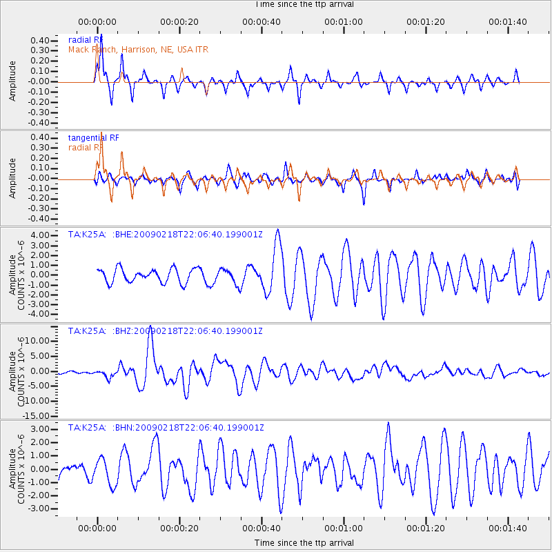
Signal To Noise
| Channel | StoN | STA | LTA |
| TA:K25A: :BHZ:20090218T22:06:40.199001Z | 3.4046926 | 1.2554517E-6 | 3.6874158E-7 |
| TA:K25A: :BHN:20090218T22:06:40.199001Z | 1.5546455 | 9.972313E-7 | 6.414525E-7 |
| TA:K25A: :BHE:20090218T22:06:40.199001Z | 1.1212779 | 7.7020115E-7 | 6.868959E-7 |
| Arrivals |
| Ps | 6.1 SECOND |
| PpPs | 18 SECOND |
| PsPs/PpSs | 24 SECOND |


