You are here: Home > Network List > TA - USArray Transportable Network (new EarthScope stations) Stations List
> Station K25A Mack Ranch, Harrison, NE, USA > Earthquake Result Viewer
K25A Mack Ranch, Harrison, NE, USA - Earthquake Result Viewer
| Earthquake location: |
Kuril Islands |
| Earthquake latitude/longitude: |
46.0/151.4 |
| Earthquake time(UTC): |
2009/04/18 (108) 19:17:58 GMT |
| Earthquake Depth: |
35 km |
| Earthquake Magnitude: |
6.3 MB, 6.3 MS, 6.6 MW, 6.4 MW |
| Earthquake Catalog/Contributor: |
WHDF/NEIC |
|
| Network: |
TA USArray Transportable Network (new EarthScope stations) |
| Station: |
K25A Mack Ranch, Harrison, NE, USA |
| Lat/Lon: |
42.61 N/103.87 W |
| Elevation: |
1437 m |
|
| Distance: |
69.3 deg |
| Az: |
49.751 deg |
| Baz: |
313.904 deg |
| Ray Param: |
0.0556732 |
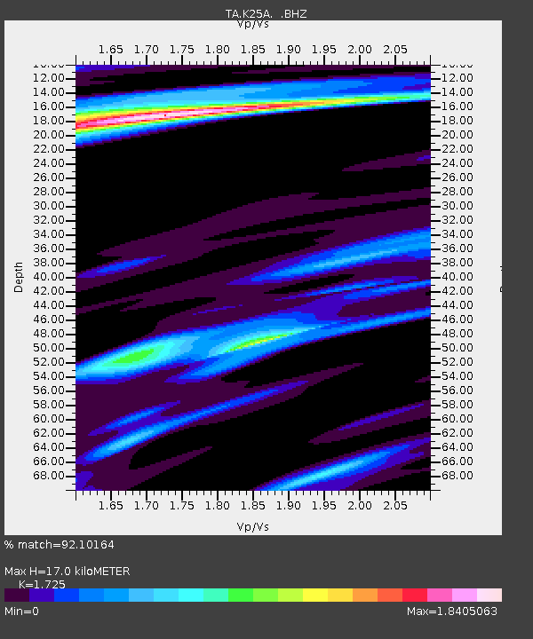
| Estimated Moho Depth: |
17.0 km |
| Estimated Crust Vp/Vs: |
1.73 |
| Assumed Crust Vp: |
6.483 km/s |
| Estimated Crust Vs: |
3.758 km/s |
| Estimated Crust Poisson's Ratio: |
0.25 |
|
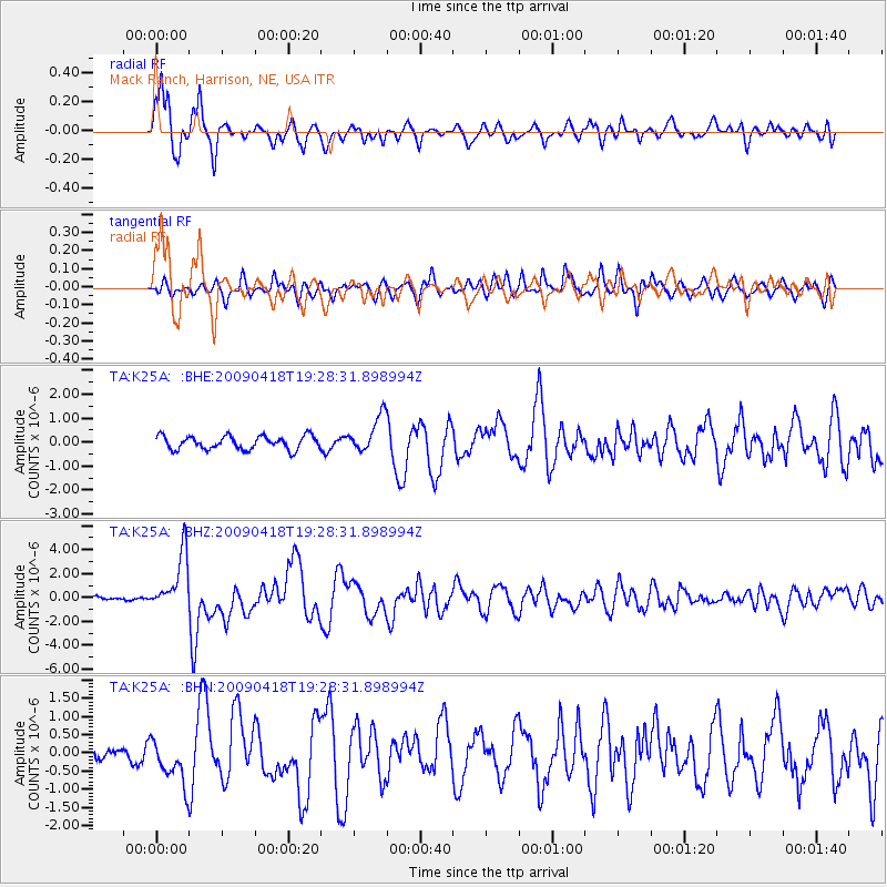
| Radial Match: |
92.10164 % |
| Radial Bump: |
365 |
| Transverse Match: |
68.73766 % |
| Transverse Bump: |
400 |
| SOD ConfigId: |
2760 |
| Insert Time: |
2010-03-06 19:32:33.245 +0000 |
| GWidth: |
2.5 |
| Max Bumps: |
400 |
| Tol: |
0.001 |
|
Signal To Noise
| Channel | StoN | STA | LTA |
| TA:K25A: :BHZ:20090418T19:28:31.898994Z | 16.000788 | 2.3671696E-6 | 1.4794081E-7 |
| TA:K25A: :BHN:20090418T19:28:31.898994Z | 2.8773777 | 6.0350214E-7 | 2.0974032E-7 |
| TA:K25A: :BHE:20090418T19:28:31.898994Z | 2.721666 | 7.6389034E-7 | 2.806701E-7 |
| Arrivals |
| Ps | 2.0 SECOND |
| PpPs | 6.9 SECOND |
| PsPs/PpSs | 8.8 SECOND |


