You are here: Home > Network List > N4 - Central and EAstern US Network Stations List
> Station W50A Signal Mountain, TN, USA > Earthquake Result Viewer
W50A Signal Mountain, TN, USA - Earthquake Result Viewer
| Earthquake location: |
Near Coast Of Central Chile |
| Earthquake latitude/longitude: |
-30.1/-71.4 |
| Earthquake time(UTC): |
2019/01/20 (020) 01:32:51 GMT |
| Earthquake Depth: |
53 km |
| Earthquake Magnitude: |
6.7 mww |
| Earthquake Catalog/Contributor: |
NEIC PDE/us |
|
| Network: |
N4 Central and EAstern US Network |
| Station: |
W50A Signal Mountain, TN, USA |
| Lat/Lon: |
35.20 N/85.31 W |
| Elevation: |
587 m |
|
| Distance: |
66.2 deg |
| Az: |
347.596 deg |
| Baz: |
166.859 deg |
| Ray Param: |
0.057637587 |
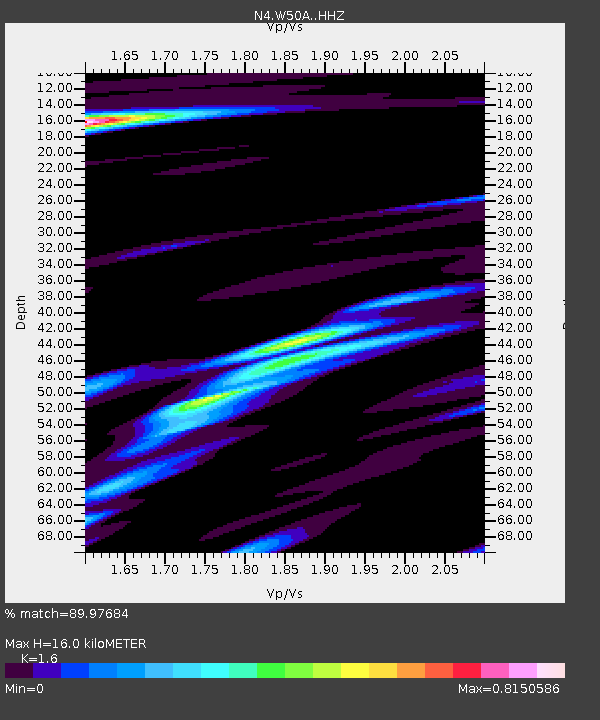
| Estimated Moho Depth: |
16.0 km |
| Estimated Crust Vp/Vs: |
1.60 |
| Assumed Crust Vp: |
6.35 km/s |
| Estimated Crust Vs: |
3.969 km/s |
| Estimated Crust Poisson's Ratio: |
0.18 |
|
| Radial Match: |
89.97684 % |
| Radial Bump: |
381 |
| Transverse Match: |
77.59892 % |
| Transverse Bump: |
400 |
| SOD ConfigId: |
13570011 |
| Insert Time: |
2019-05-02 08:30:36.636 +0000 |
| GWidth: |
2.5 |
| Max Bumps: |
400 |
| Tol: |
0.001 |
|

Signal To Noise
| Channel | StoN | STA | LTA |
| N4:W50A: :HHZ:20190120T01:43:03.269978Z | 7.759791 | 7.641618E-6 | 9.847711E-7 |
| N4:W50A: :HHN:20190120T01:43:03.269978Z | 20.301489 | 3.2776454E-6 | 1.6144853E-7 |
| N4:W50A: :HHE:20190120T01:43:03.269978Z | 3.0042846 | 6.512121E-7 | 2.1676112E-7 |
| Arrivals |
| Ps | 1.6 SECOND |
| PpPs | 6.3 SECOND |
| PsPs/PpSs | 7.8 SECOND |


