You are here: Home > Network List > TA - USArray Transportable Network (new EarthScope stations) Stations List
> Station O48B Farmland, IN, USA > Earthquake Result Viewer
O48B Farmland, IN, USA - Earthquake Result Viewer
| Earthquake location: |
Near Coast Of Central Chile |
| Earthquake latitude/longitude: |
-30.1/-71.4 |
| Earthquake time(UTC): |
2019/01/20 (020) 01:32:51 GMT |
| Earthquake Depth: |
53 km |
| Earthquake Magnitude: |
6.7 mww |
| Earthquake Catalog/Contributor: |
NEIC PDE/us |
|
| Network: |
TA USArray Transportable Network (new EarthScope stations) |
| Station: |
O48B Farmland, IN, USA |
| Lat/Lon: |
40.26 N/85.16 W |
| Elevation: |
300 m |
|
| Distance: |
71.1 deg |
| Az: |
348.931 deg |
| Baz: |
167.44 deg |
| Ray Param: |
0.054428212 |
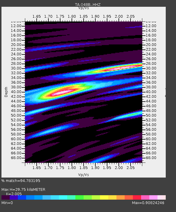
| Estimated Moho Depth: |
29.75 km |
| Estimated Crust Vp/Vs: |
2.01 |
| Assumed Crust Vp: |
6.498 km/s |
| Estimated Crust Vs: |
3.241 km/s |
| Estimated Crust Poisson's Ratio: |
0.33 |
|
| Radial Match: |
94.783195 % |
| Radial Bump: |
347 |
| Transverse Match: |
77.16106 % |
| Transverse Bump: |
400 |
| SOD ConfigId: |
13570011 |
| Insert Time: |
2019-05-02 08:33:41.304 +0000 |
| GWidth: |
2.5 |
| Max Bumps: |
400 |
| Tol: |
0.001 |
|

Signal To Noise
| Channel | StoN | STA | LTA |
| TA:O48B: :HHZ:20190120T01:43:33.659993Z | 19.310217 | 8.241916E-6 | 4.268163E-7 |
| TA:O48B: :HHN:20190120T01:43:33.659993Z | 9.998511 | 3.6061895E-6 | 3.606726E-7 |
| TA:O48B: :HHE:20190120T01:43:33.659993Z | 1.7128532 | 7.0555944E-7 | 4.1192058E-7 |
| Arrivals |
| Ps | 4.8 SECOND |
| PpPs | 13 SECOND |
| PsPs/PpSs | 18 SECOND |


