You are here: Home > Network List > TA - USArray Transportable Network (new EarthScope stations) Stations List
> Station T25A Trinidad, CO, USA > Earthquake Result Viewer
T25A Trinidad, CO, USA - Earthquake Result Viewer
| Earthquake location: |
Near Coast Of Central Chile |
| Earthquake latitude/longitude: |
-30.1/-71.4 |
| Earthquake time(UTC): |
2019/01/20 (020) 01:32:51 GMT |
| Earthquake Depth: |
53 km |
| Earthquake Magnitude: |
6.7 mww |
| Earthquake Catalog/Contributor: |
NEIC PDE/us |
|
| Network: |
TA USArray Transportable Network (new EarthScope stations) |
| Station: |
T25A Trinidad, CO, USA |
| Lat/Lon: |
37.14 N/104.41 W |
| Elevation: |
2017 m |
|
| Distance: |
73.7 deg |
| Az: |
333.038 deg |
| Baz: |
150.54 deg |
| Ray Param: |
0.052750003 |
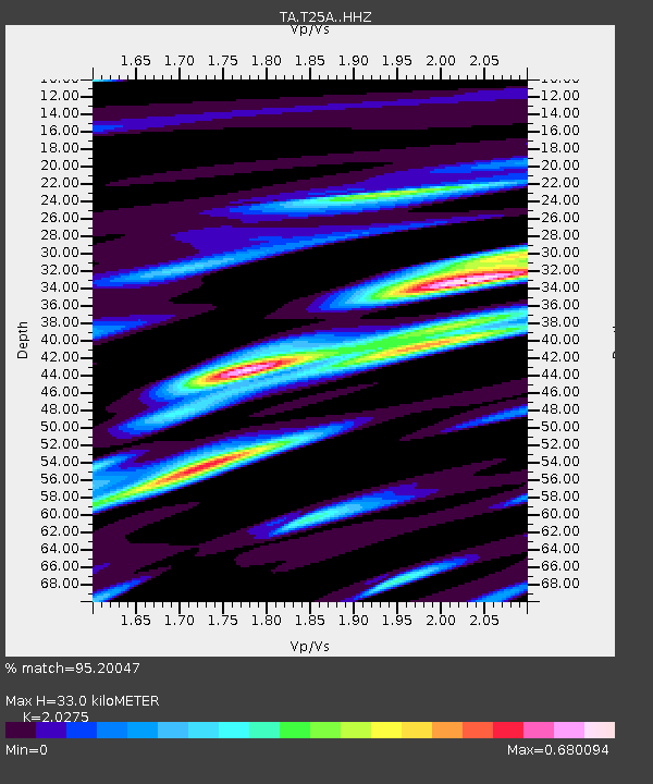
| Estimated Moho Depth: |
33.0 km |
| Estimated Crust Vp/Vs: |
2.03 |
| Assumed Crust Vp: |
6.316 km/s |
| Estimated Crust Vs: |
3.115 km/s |
| Estimated Crust Poisson's Ratio: |
0.34 |
|
| Radial Match: |
95.20047 % |
| Radial Bump: |
286 |
| Transverse Match: |
90.80111 % |
| Transverse Bump: |
400 |
| SOD ConfigId: |
13570011 |
| Insert Time: |
2019-05-02 08:33:44.091 +0000 |
| GWidth: |
2.5 |
| Max Bumps: |
400 |
| Tol: |
0.001 |
|
Signal To Noise
| Channel | StoN | STA | LTA |
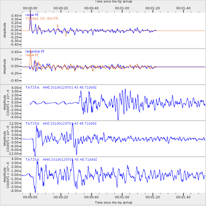
| TA:T25A: :HHZ:20190120T01:43:48.71999Z | 28.268486 | 6.3839225E-6 | 2.2583178E-7 |
| TA:T25A: :HHN:20190120T01:43:48.71999Z | 10.651252 | 2.0463262E-6 | 1.9212074E-7 |
| TA:T25A: :HHE:20190120T01:43:48.71999Z | 5.6576033 | 1.2848731E-6 | 2.2710555E-7 |
| Arrivals |
| Ps | 5.5 SECOND |
| PpPs | 15 SECOND |
| PsPs/PpSs | 21 SECOND |


