You are here: Home > Network List > UW - Pacific Northwest Regional Seismic Network Stations List
> Station UMAT Pilot Rock, OR, USA > Earthquake Result Viewer
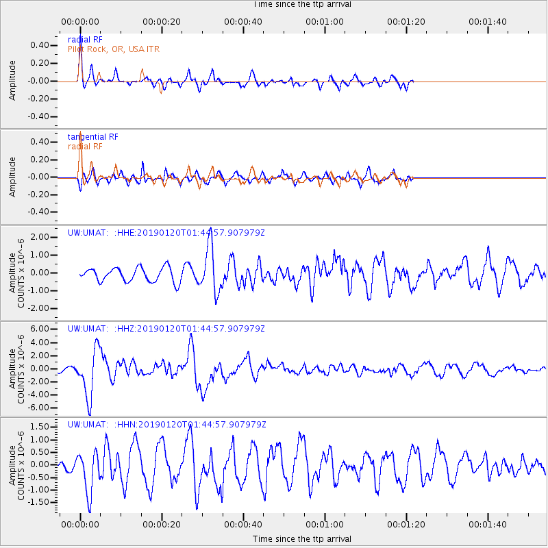
UMAT Pilot Rock, OR, USA - Earthquake Result Viewer
*The percent match for this event was below the threshold and hence no stack was calculated.
| Earthquake location: |
Near Coast Of Central Chile |
| Earthquake latitude/longitude: |
-30.1/-71.4 |
| Earthquake time(UTC): |
2019/01/20 (020) 01:32:51 GMT |
| Earthquake Depth: |
53 km |
| Earthquake Magnitude: |
6.7 mww |
| Earthquake Catalog/Contributor: |
NEIC PDE/us |
|
| Network: |
UW Pacific Northwest Regional Seismic Network |
| Station: |
UMAT Pilot Rock, OR, USA |
| Lat/Lon: |
45.29 N/118.96 W |
| Elevation: |
1318 m |
|
| Distance: |
86.6 deg |
| Az: |
328.555 deg |
| Baz: |
140.162 deg |
| Ray Param: |
$rayparam |
*The percent match for this event was below the threshold and hence was not used in the summary stack. |
|
| Radial Match: |
78.53362 % |
| Radial Bump: |
357 |
| Transverse Match: |
72.11774 % |
| Transverse Bump: |
400 |
| SOD ConfigId: |
13570011 |
| Insert Time: |
2019-05-02 08:34:58.684 +0000 |
| GWidth: |
2.5 |
| Max Bumps: |
400 |
| Tol: |
0.001 |
|
Signal To Noise
| Channel | StoN | STA | LTA |
| UW:UMAT: :HHZ:20190120T01:44:57.907979Z | 6.9577627 | 3.7006678E-6 | 5.318761E-7 |
| UW:UMAT: :HHN:20190120T01:44:57.907979Z | 3.0130956 | 8.5165385E-7 | 2.8265077E-7 |
| UW:UMAT: :HHE:20190120T01:44:57.907979Z | 3.3575904 | 1.3239846E-6 | 3.9432584E-7 |
| Arrivals |
| Ps | |
| PpPs | |
| PsPs/PpSs | |


