You are here: Home > Network List > WU - The Southern Ontario Seismic Network Stations List
> Station DELO Deloro Mine, Ontario, Canada > Earthquake Result Viewer
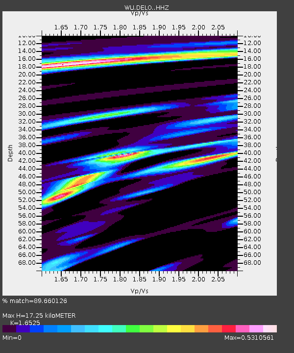
DELO Deloro Mine, Ontario, Canada - Earthquake Result Viewer
| Earthquake location: |
Near Coast Of Central Chile |
| Earthquake latitude/longitude: |
-30.1/-71.4 |
| Earthquake time(UTC): |
2019/01/20 (020) 01:32:51 GMT |
| Earthquake Depth: |
53 km |
| Earthquake Magnitude: |
6.7 mww |
| Earthquake Catalog/Contributor: |
NEIC PDE/us |
|
| Network: |
WU The Southern Ontario Seismic Network |
| Station: |
DELO Deloro Mine, Ontario, Canada |
| Lat/Lon: |
44.52 N/77.62 W |
| Elevation: |
213 m |
|
| Distance: |
74.4 deg |
| Az: |
355.404 deg |
| Baz: |
174.428 deg |
| Ray Param: |
0.052223194 |
| Estimated Moho Depth: |
17.25 km |
| Estimated Crust Vp/Vs: |
1.65 |
| Assumed Crust Vp: |
6.577 km/s |
| Estimated Crust Vs: |
3.98 km/s |
| Estimated Crust Poisson's Ratio: |
0.21 |
|
| Radial Match: |
89.660126 % |
| Radial Bump: |
305 |
| Transverse Match: |
80.69727 % |
| Transverse Bump: |
400 |
| SOD ConfigId: |
13570011 |
| Insert Time: |
2019-05-02 08:35:14.125 +0000 |
| GWidth: |
2.5 |
| Max Bumps: |
400 |
| Tol: |
0.001 |
|

Signal To Noise
| Channel | StoN | STA | LTA |
| WU:DELO: :HHZ:20190120T01:43:53.279988Z | 12.221024 | 5.8870705E-6 | 4.8171665E-7 |
| WU:DELO: :HHN:20190120T01:43:53.279988Z | 7.384152 | 2.752155E-6 | 3.7271104E-7 |
| WU:DELO: :HHE:20190120T01:43:53.279988Z | 1.0319676 | 3.5142907E-7 | 3.405427E-7 |
| Arrivals |
| Ps | 1.8 SECOND |
| PpPs | 6.7 SECOND |
| PsPs/PpSs | 8.5 SECOND |


