You are here: Home > Network List > TA - USArray Transportable Network (new EarthScope stations) Stations List
> Station F24A Ekalaka, MT, USA > Earthquake Result Viewer
F24A Ekalaka, MT, USA - Earthquake Result Viewer
| Earthquake location: |
Samoa Islands Region |
| Earthquake latitude/longitude: |
-15.5/-172.1 |
| Earthquake time(UTC): |
2009/09/29 (272) 17:48:10 GMT |
| Earthquake Depth: |
18 km |
| Earthquake Magnitude: |
7.1 MB, 8.1 MS, 8.1 MW, 8.0 MW |
| Earthquake Catalog/Contributor: |
WHDF/NEIC |
|
| Network: |
TA USArray Transportable Network (new EarthScope stations) |
| Station: |
F24A Ekalaka, MT, USA |
| Lat/Lon: |
45.85 N/104.44 W |
| Elevation: |
1105 m |
|
| Distance: |
86.2 deg |
| Az: |
40.386 deg |
| Baz: |
243.341 deg |
| Ray Param: |
0.044215895 |
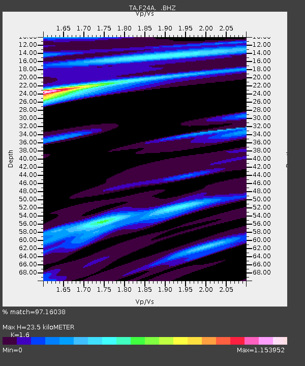
| Estimated Moho Depth: |
23.5 km |
| Estimated Crust Vp/Vs: |
1.60 |
| Assumed Crust Vp: |
6.242 km/s |
| Estimated Crust Vs: |
3.901 km/s |
| Estimated Crust Poisson's Ratio: |
0.18 |
|
| Radial Match: |
97.16038 % |
| Radial Bump: |
397 |
| Transverse Match: |
95.186844 % |
| Transverse Bump: |
400 |
| SOD ConfigId: |
2622 |
| Insert Time: |
2010-03-06 19:34:02.985 +0000 |
| GWidth: |
2.5 |
| Max Bumps: |
400 |
| Tol: |
0.001 |
|

Signal To Noise
| Channel | StoN | STA | LTA |
| TA:F24A: :BHZ:20090929T18:00:19.62501Z | 9.803761 | 3.3928172E-6 | 3.4607302E-7 |
| TA:F24A: :BHN:20090929T18:00:19.62501Z | 1.1680455 | 5.5482826E-7 | 4.750057E-7 |
| TA:F24A: :BHE:20090929T18:00:19.62501Z | 1.9667277 | 8.692532E-7 | 4.419794E-7 |
| Arrivals |
| Ps | 2.3 SECOND |
| PpPs | 9.6 SECOND |
| PsPs/PpSs | 12 SECOND |


