You are here: Home > Network List > TA - USArray Transportable Network (new EarthScope stations) Stations List
> Station L15K Ungalak Mountain, AK, USA > Earthquake Result Viewer
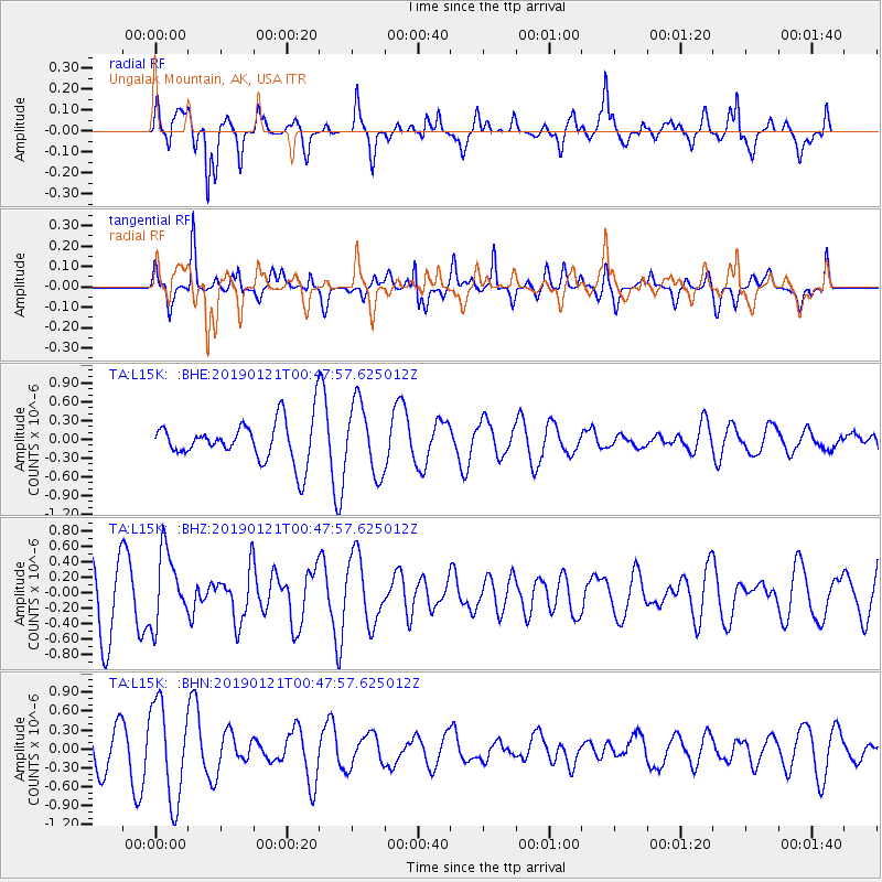
L15K Ungalak Mountain, AK, USA - Earthquake Result Viewer
*The percent match for this event was below the threshold and hence no stack was calculated.
| Earthquake location: |
Southeast Of Loyalty Islands |
| Earthquake latitude/longitude: |
-21.9/169.0 |
| Earthquake time(UTC): |
2019/01/21 (021) 00:35:45 GMT |
| Earthquake Depth: |
10 km |
| Earthquake Magnitude: |
5.5 Mww |
| Earthquake Catalog/Contributor: |
NEIC PDE/us |
|
| Network: |
TA USArray Transportable Network (new EarthScope stations) |
| Station: |
L15K Ungalak Mountain, AK, USA |
| Lat/Lon: |
61.68 N/161.49 W |
| Elevation: |
219 m |
|
| Distance: |
86.6 deg |
| Az: |
13.606 deg |
| Baz: |
207.265 deg |
| Ray Param: |
$rayparam |
*The percent match for this event was below the threshold and hence was not used in the summary stack. |
|
| Radial Match: |
57.468807 % |
| Radial Bump: |
400 |
| Transverse Match: |
63.222496 % |
| Transverse Bump: |
400 |
| SOD ConfigId: |
13570011 |
| Insert Time: |
2019-05-02 08:39:34.844 +0000 |
| GWidth: |
2.5 |
| Max Bumps: |
400 |
| Tol: |
0.001 |
|
Signal To Noise
| Channel | StoN | STA | LTA |
| TA:L15K: :BHZ:20190121T00:47:57.625012Z | 1.1507629 | 4.623312E-7 | 4.017606E-7 |
| TA:L15K: :BHN:20190121T00:47:57.625012Z | 3.185573 | 7.68E-7 | 2.4108692E-7 |
| TA:L15K: :BHE:20190121T00:47:57.625012Z | 1.7285352 | 5.635606E-7 | 3.2603367E-7 |
| Arrivals |
| Ps | |
| PpPs | |
| PsPs/PpSs | |


