You are here: Home > Network List > TA - USArray Transportable Network (new EarthScope stations) Stations List
> Station F24A Ekalaka, MT, USA > Earthquake Result Viewer
F24A Ekalaka, MT, USA - Earthquake Result Viewer

| Earthquake location: |
Crete, Greece |
| Earthquake latitude/longitude: |
34.2/25.5 |
| Earthquake time(UTC): |
2009/07/01 (182) 09:30:10 GMT |
| Earthquake Depth: |
19 km |
| Earthquake Magnitude: |
6.1 MB, 6.3 MS, 6.4 MW, 6.4 MW |
| Earthquake Catalog/Contributor: |
WHDF/NEIC |
|
| Network: |
TA USArray Transportable Network (new EarthScope stations) |
| Station: |
F24A Ekalaka, MT, USA |
| Lat/Lon: |
45.85 N/104.44 W |
| Elevation: |
1105 m |
|
| Distance: |
88.4 deg |
| Az: |
327.565 deg |
| Baz: |
39.51 deg |
| Ray Param: |
0.042595565 |
| Estimated Moho Depth: |
69.75 km |
| Estimated Crust Vp/Vs: |
1.62 |
| Assumed Crust Vp: |
6.242 km/s |
| Estimated Crust Vs: |
3.853 km/s |
| Estimated Crust Poisson's Ratio: |
0.19 |
|
| Radial Match: |
81.690155 % |
| Radial Bump: |
400 |
| Transverse Match: |
74.70548 % |
| Transverse Bump: |
400 |
| SOD ConfigId: |
2648 |
| Insert Time: |
2010-03-06 19:34:07.521 +0000 |
| GWidth: |
2.5 |
| Max Bumps: |
400 |
| Tol: |
0.001 |
|
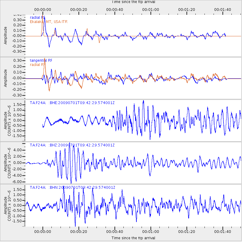
Signal To Noise
| Channel | StoN | STA | LTA |
| TA:F24A: :BHZ:20090701T09:42:29.574001Z | 2.7448537 | 4.093254E-7 | 1.4912466E-7 |
| TA:F24A: :BHN:20090701T09:42:29.574001Z | 1.0889069 | 2.5795106E-7 | 2.3688993E-7 |
| TA:F24A: :BHE:20090701T09:42:29.574001Z | 1.0828615 | 2.590359E-7 | 2.3921422E-7 |
| Arrivals |
| Ps | 7.1 SECOND |
| PpPs | 29 SECOND |
| PsPs/PpSs | 36 SECOND |


