You are here: Home > Network List > TA - USArray Transportable Network (new EarthScope stations) Stations List
> Station F24A Ekalaka, MT, USA > Earthquake Result Viewer
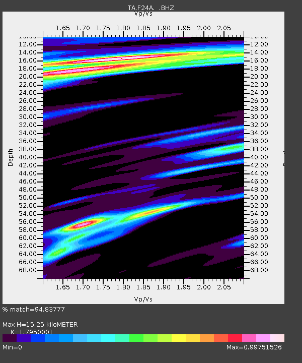
F24A Ekalaka, MT, USA - Earthquake Result Viewer
| Earthquake location: |
Kuril Islands |
| Earthquake latitude/longitude: |
46.0/151.5 |
| Earthquake time(UTC): |
2009/04/07 (097) 04:23:33 GMT |
| Earthquake Depth: |
31 km |
| Earthquake Magnitude: |
6.5 MB, 6.8 MS, 6.9 MW, 6.9 MW |
| Earthquake Catalog/Contributor: |
WHDF/NEIC |
|
| Network: |
TA USArray Transportable Network (new EarthScope stations) |
| Station: |
F24A Ekalaka, MT, USA |
| Lat/Lon: |
45.85 N/104.44 W |
| Elevation: |
1105 m |
|
| Distance: |
66.7 deg |
| Az: |
47.593 deg |
| Baz: |
312.636 deg |
| Ray Param: |
0.057385728 |
| Estimated Moho Depth: |
15.25 km |
| Estimated Crust Vp/Vs: |
1.80 |
| Assumed Crust Vp: |
6.242 km/s |
| Estimated Crust Vs: |
3.477 km/s |
| Estimated Crust Poisson's Ratio: |
0.27 |
|
| Radial Match: |
94.83777 % |
| Radial Bump: |
335 |
| Transverse Match: |
79.18025 % |
| Transverse Bump: |
376 |
| SOD ConfigId: |
2658 |
| Insert Time: |
2010-03-06 19:34:11.480 +0000 |
| GWidth: |
2.5 |
| Max Bumps: |
400 |
| Tol: |
0.001 |
|

Signal To Noise
| Channel | StoN | STA | LTA |
| TA:F24A: :BHZ:20090407T04:33:50.248999Z | 19.589033 | 7.7981085E-6 | 3.980854E-7 |
| TA:F24A: :BHN:20090407T04:33:50.248999Z | 2.920703 | 2.0304874E-6 | 6.95205E-7 |
| TA:F24A: :BHE:20090407T04:33:50.248999Z | 1.9427282 | 1.7797936E-6 | 9.161311E-7 |
| Arrivals |
| Ps | 2.0 SECOND |
| PpPs | 6.6 SECOND |
| PsPs/PpSs | 8.6 SECOND |


