You are here: Home > Network List > TA - USArray Transportable Network (new EarthScope stations) Stations List
> Station D25K Kavik River, AK, USA > Earthquake Result Viewer
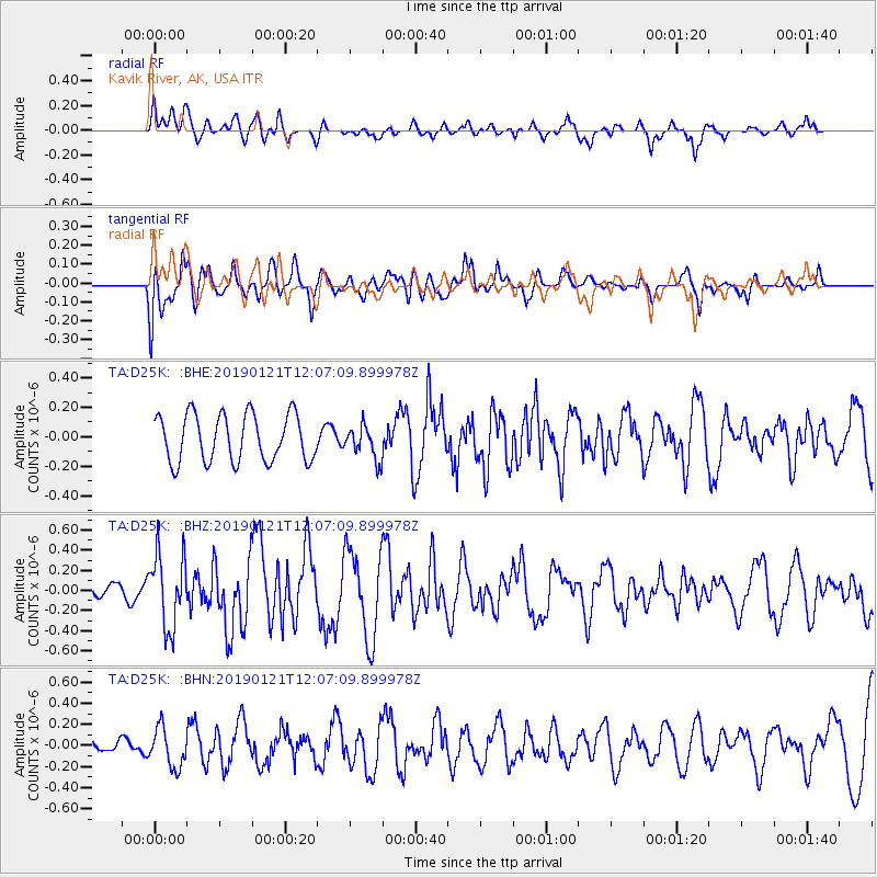
D25K Kavik River, AK, USA - Earthquake Result Viewer
*The percent match for this event was below the threshold and hence no stack was calculated.
| Earthquake location: |
Near Coast Of Oaxaca, Mexico |
| Earthquake latitude/longitude: |
15.6/-94.7 |
| Earthquake time(UTC): |
2019/01/21 (021) 11:57:17 GMT |
| Earthquake Depth: |
10 km |
| Earthquake Magnitude: |
5.8 Mww |
| Earthquake Catalog/Contributor: |
NEIC PDE/us |
|
| Network: |
TA USArray Transportable Network (new EarthScope stations) |
| Station: |
D25K Kavik River, AK, USA |
| Lat/Lon: |
69.32 N/146.38 W |
| Elevation: |
770 m |
|
| Distance: |
62.5 deg |
| Az: |
341.698 deg |
| Baz: |
121.562 deg |
| Ray Param: |
$rayparam |
*The percent match for this event was below the threshold and hence was not used in the summary stack. |
|
| Radial Match: |
58.93071 % |
| Radial Bump: |
400 |
| Transverse Match: |
57.583103 % |
| Transverse Bump: |
400 |
| SOD ConfigId: |
13570011 |
| Insert Time: |
2019-05-02 08:49:59.876 +0000 |
| GWidth: |
2.5 |
| Max Bumps: |
400 |
| Tol: |
0.001 |
|
Signal To Noise
| Channel | StoN | STA | LTA |
| TA:D25K: :BHZ:20190121T12:07:09.899978Z | 2.1425676 | 3.6821822E-7 | 1.7185837E-7 |
| TA:D25K: :BHN:20190121T12:07:09.899978Z | 1.728139 | 1.85674E-7 | 1.0744158E-7 |
| TA:D25K: :BHE:20190121T12:07:09.899978Z | 0.70551527 | 1.123652E-7 | 1.5926686E-7 |
| Arrivals |
| Ps | |
| PpPs | |
| PsPs/PpSs | |


