You are here: Home > Network List > TA - USArray Transportable Network (new EarthScope stations) Stations List
> Station F24A Ekalaka, MT, USA > Earthquake Result Viewer
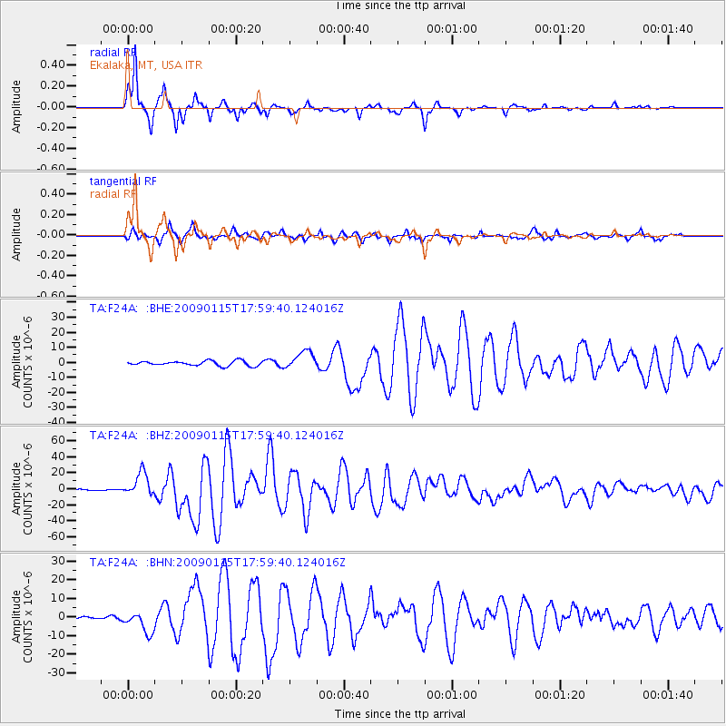
F24A Ekalaka, MT, USA - Earthquake Result Viewer
*The percent match for this event was below the threshold and hence no stack was calculated.
| Earthquake location: |
East Of Kuril Islands |
| Earthquake latitude/longitude: |
46.9/155.2 |
| Earthquake time(UTC): |
2009/01/15 (015) 17:49:39 GMT |
| Earthquake Depth: |
36 km |
| Earthquake Magnitude: |
6.9 MB, 7.5 MS, 7.4 MW, 7.4 MW |
| Earthquake Catalog/Contributor: |
WHDF/NEIC |
|
| Network: |
TA USArray Transportable Network (new EarthScope stations) |
| Station: |
F24A Ekalaka, MT, USA |
| Lat/Lon: |
45.85 N/104.44 W |
| Elevation: |
1105 m |
|
| Distance: |
64.3 deg |
| Az: |
49.725 deg |
| Baz: |
311.493 deg |
| Ray Param: |
$rayparam |
*The percent match for this event was below the threshold and hence was not used in the summary stack. |
|
| Radial Match: |
98.03418 % |
| Radial Bump: |
285 |
| Transverse Match: |
92.69295 % |
| Transverse Bump: |
400 |
| SOD ConfigId: |
2658 |
| Insert Time: |
2010-03-06 19:35:22.888 +0000 |
| GWidth: |
2.5 |
| Max Bumps: |
400 |
| Tol: |
0.001 |
|
Signal To Noise
| Channel | StoN | STA | LTA |
| TA:F24A: :BHZ:20090115T17:59:40.124016Z | 16.072832 | 1.4855809E-5 | 9.2428076E-7 |
| TA:F24A: :BHN:20090115T17:59:40.124016Z | 5.0240703 | 5.75602E-6 | 1.1456887E-6 |
| TA:F24A: :BHE:20090115T17:59:40.124016Z | 3.7018456 | 5.9216463E-6 | 1.599647E-6 |
| Arrivals |
| Ps | |
| PpPs | |
| PsPs/PpSs | |


