You are here: Home > Network List > TS - TERRAscope (Southern California Seismic Network) Stations List
> Station CALB Calabasas, California, USA > Earthquake Result Viewer
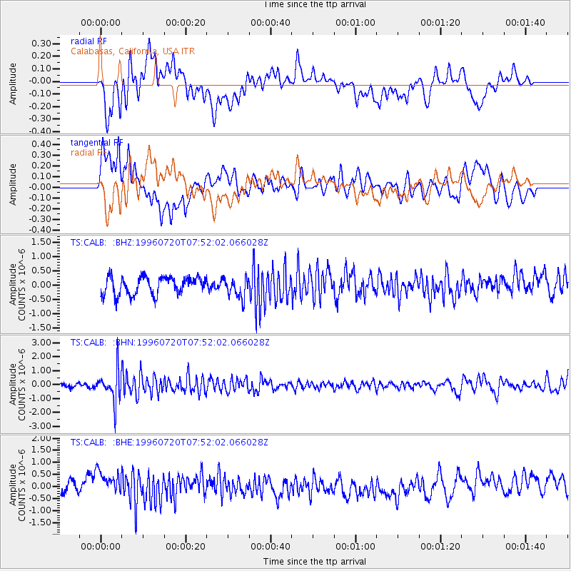
CALB Calabasas, California, USA - Earthquake Result Viewer
*The percent match for this event was below the threshold and hence no stack was calculated.
| Earthquake location: |
Fiji Islands Region |
| Earthquake latitude/longitude: |
-19.8/-177.6 |
| Earthquake time(UTC): |
1996/07/20 (202) 07:41:15 GMT |
| Earthquake Depth: |
357 km |
| Earthquake Magnitude: |
5.7 MB, 5.9 UNKNOWN, 5.8 MW |
| Earthquake Catalog/Contributor: |
WHDF/NEIC |
|
| Network: |
TS TERRAscope (Southern California Seismic Network) |
| Station: |
CALB Calabasas, California, USA |
| Lat/Lon: |
34.14 N/118.63 W |
| Elevation: |
0.0 m |
|
| Distance: |
77.7 deg |
| Az: |
46.706 deg |
| Baz: |
235.713 deg |
| Ray Param: |
$rayparam |
*The percent match for this event was below the threshold and hence was not used in the summary stack. |
|
| Radial Match: |
48.163906 % |
| Radial Bump: |
400 |
| Transverse Match: |
39.57006 % |
| Transverse Bump: |
400 |
| SOD ConfigId: |
4480 |
| Insert Time: |
2010-02-26 14:04:10.254 +0000 |
| GWidth: |
2.5 |
| Max Bumps: |
400 |
| Tol: |
0.001 |
|
Signal To Noise
| Channel | StoN | STA | LTA |
| TS:CALB: :BHN:19960720T07:52:02.066028Z | 4.936066 | 1.1627186E-6 | 2.355557E-7 |
| TS:CALB: :BHE:19960720T07:52:02.066028Z | 2.2804227 | 7.413466E-7 | 3.2509175E-7 |
| TS:CALB: :BHZ:19960720T07:52:02.066028Z | 1.1779996 | 3.6174887E-7 | 3.0708745E-7 |
| Arrivals |
| Ps | |
| PpPs | |
| PsPs/PpSs | |


