You are here: Home > Network List > TA - USArray Transportable Network (new EarthScope stations) Stations List
> Station F23A Volborg, MT, USA > Earthquake Result Viewer
F23A Volborg, MT, USA - Earthquake Result Viewer
| Earthquake location: |
Southwestern Ryukyu Isl., Japan |
| Earthquake latitude/longitude: |
23.4/123.7 |
| Earthquake time(UTC): |
2009/08/17 (229) 10:15:05 GMT |
| Earthquake Depth: |
10 km |
| Earthquake Magnitude: |
5.7 MB |
| Earthquake Catalog/Contributor: |
WHDF/NEIC |
|
| Network: |
TA USArray Transportable Network (new EarthScope stations) |
| Station: |
F23A Volborg, MT, USA |
| Lat/Lon: |
45.72 N/105.41 W |
| Elevation: |
953 m |
|
| Distance: |
98.0 deg |
| Az: |
32.334 deg |
| Baz: |
315.466 deg |
| Ray Param: |
0.040040385 |
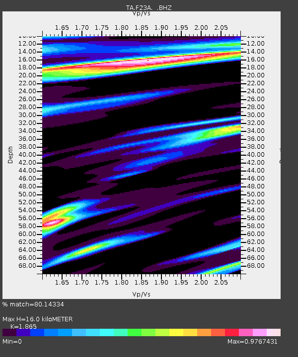
| Estimated Moho Depth: |
16.0 km |
| Estimated Crust Vp/Vs: |
1.87 |
| Assumed Crust Vp: |
6.242 km/s |
| Estimated Crust Vs: |
3.347 km/s |
| Estimated Crust Poisson's Ratio: |
0.30 |
|
| Radial Match: |
80.14334 % |
| Radial Bump: |
307 |
| Transverse Match: |
52.49592 % |
| Transverse Bump: |
400 |
| SOD ConfigId: |
2622 |
| Insert Time: |
2010-03-06 19:35:46.670 +0000 |
| GWidth: |
2.5 |
| Max Bumps: |
400 |
| Tol: |
0.001 |
|

Signal To Noise
| Channel | StoN | STA | LTA |
| TA:F23A: :BHZ:20090817T10:28:09.499014Z | 1.4283235 | 3.54839E-7 | 2.484304E-7 |
| TA:F23A: :BHN:20090817T10:28:09.499014Z | 0.8358673 | 1.2984042E-7 | 1.5533617E-7 |
| TA:F23A: :BHE:20090817T10:28:09.499014Z | 1.583761 | 3.0865976E-7 | 1.9489038E-7 |
| Arrivals |
| Ps | 2.3 SECOND |
| PpPs | 7.2 SECOND |
| PsPs/PpSs | 9.5 SECOND |


