You are here: Home > Network List > TA - USArray Transportable Network (new EarthScope stations) Stations List
> Station F23A Volborg, MT, USA > Earthquake Result Viewer
F23A Volborg, MT, USA - Earthquake Result Viewer
| Earthquake location: |
Kermadec Islands Region |
| Earthquake latitude/longitude: |
-27.4/-176.3 |
| Earthquake time(UTC): |
2009/02/18 (049) 21:53:45 GMT |
| Earthquake Depth: |
25 km |
| Earthquake Magnitude: |
6.8 MB, 7.2 MS, 6.9 MW, 6.9 MW |
| Earthquake Catalog/Contributor: |
WHDF/NEIC |
|
| Network: |
TA USArray Transportable Network (new EarthScope stations) |
| Station: |
F23A Volborg, MT, USA |
| Lat/Lon: |
45.72 N/105.41 W |
| Elevation: |
953 m |
|
| Distance: |
97.1 deg |
| Az: |
41.85 deg |
| Baz: |
237.838 deg |
| Ray Param: |
0.040309113 |
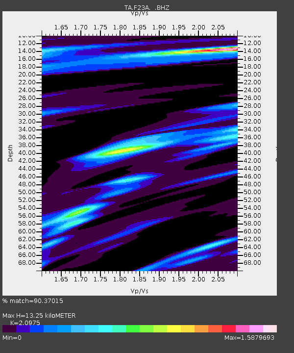
| Estimated Moho Depth: |
13.25 km |
| Estimated Crust Vp/Vs: |
2.10 |
| Assumed Crust Vp: |
6.242 km/s |
| Estimated Crust Vs: |
2.976 km/s |
| Estimated Crust Poisson's Ratio: |
0.35 |
|
| Radial Match: |
90.37015 % |
| Radial Bump: |
256 |
| Transverse Match: |
78.287605 % |
| Transverse Bump: |
303 |
| SOD ConfigId: |
2658 |
| Insert Time: |
2010-03-06 19:35:51.624 +0000 |
| GWidth: |
2.5 |
| Max Bumps: |
400 |
| Tol: |
0.001 |
|
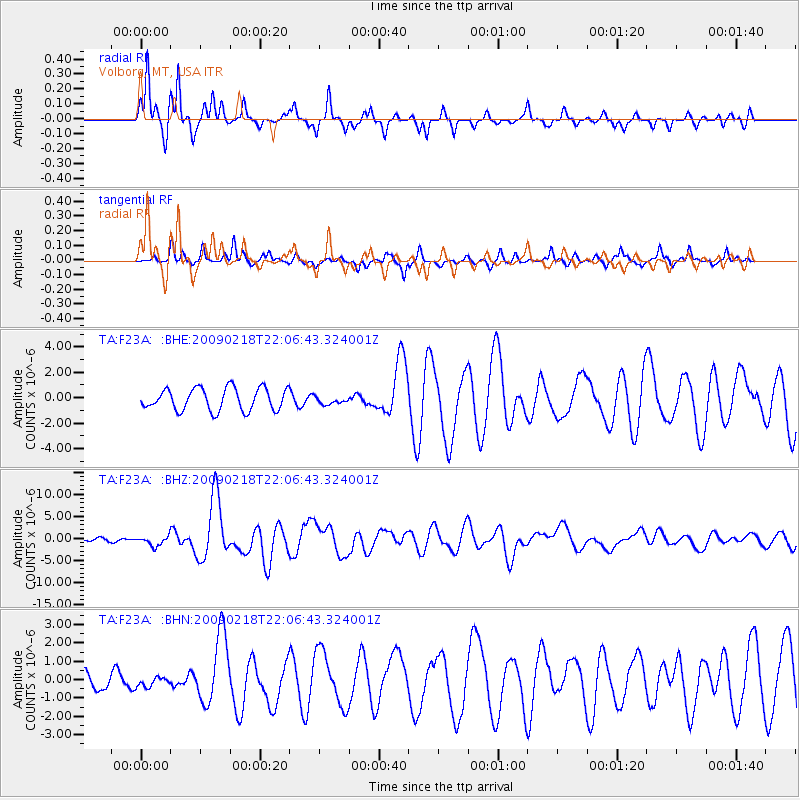
Signal To Noise
| Channel | StoN | STA | LTA |
| TA:F23A: :BHZ:20090218T22:06:43.324001Z | 3.1715872 | 1.1201157E-6 | 3.5317197E-7 |
| TA:F23A: :BHN:20090218T22:06:43.324001Z | 0.45549467 | 2.421026E-7 | 5.3151575E-7 |
| TA:F23A: :BHE:20090218T22:06:43.324001Z | 0.339857 | 2.9425888E-7 | 8.6583145E-7 |
| Arrivals |
| Ps | 2.4 SECOND |
| PpPs | 6.5 SECOND |
| PsPs/PpSs | 8.8 SECOND |


