You are here: Home > Network List > MM - Myanmar National Seismic Network Stations List
> Station TGI Taung Gyi, Myanmar > Earthquake Result Viewer
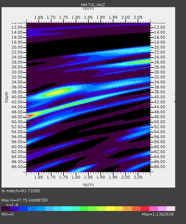
TGI Taung Gyi, Myanmar - Earthquake Result Viewer
| Earthquake location: |
Sumba Region, Indonesia |
| Earthquake latitude/longitude: |
-10.5/119.0 |
| Earthquake time(UTC): |
2019/01/22 (022) 05:10:03 GMT |
| Earthquake Depth: |
27 km |
| Earthquake Magnitude: |
6.4 Mww |
| Earthquake Catalog/Contributor: |
NEIC PDE/us |
|
| Network: |
MM Myanmar National Seismic Network |
| Station: |
TGI Taung Gyi, Myanmar |
| Lat/Lon: |
20.77 N/97.03 E |
| Elevation: |
1458 m |
|
| Distance: |
37.8 deg |
| Az: |
325.147 deg |
| Baz: |
143.084 deg |
| Ray Param: |
0.07586601 |
| Estimated Moho Depth: |
47.75 km |
| Estimated Crust Vp/Vs: |
1.60 |
| Assumed Crust Vp: |
6.316 km/s |
| Estimated Crust Vs: |
3.947 km/s |
| Estimated Crust Poisson's Ratio: |
0.18 |
|
| Radial Match: |
93.72095 % |
| Radial Bump: |
237 |
| Transverse Match: |
73.56919 % |
| Transverse Bump: |
400 |
| SOD ConfigId: |
13570011 |
| Insert Time: |
2019-05-02 08:56:56.141 +0000 |
| GWidth: |
2.5 |
| Max Bumps: |
400 |
| Tol: |
0.001 |
|

Signal To Noise
| Channel | StoN | STA | LTA |
| MM:TGI: :HHZ:20190122T05:16:47.279985Z | 38.380623 | 2.882146E-6 | 7.509378E-8 |
| MM:TGI: :HHN:20190122T05:16:47.279985Z | 19.742329 | 1.3992417E-6 | 7.087521E-8 |
| MM:TGI: :HHE:20190122T05:16:47.279985Z | 17.75214 | 1.098506E-6 | 6.18802E-8 |
| Arrivals |
| Ps | 4.9 SECOND |
| PpPs | 18 SECOND |
| PsPs/PpSs | 23 SECOND |


