You are here: Home > Network List > TA - USArray Transportable Network (new EarthScope stations) Stations List
> Station B18K Kokolik River, AK, USA > Earthquake Result Viewer
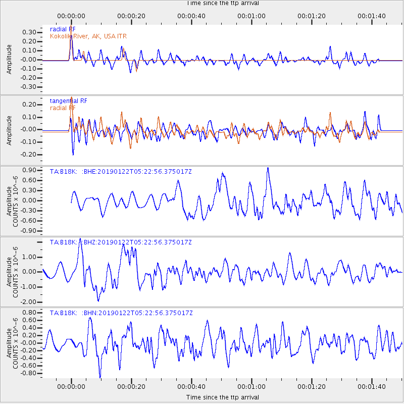
B18K Kokolik River, AK, USA - Earthquake Result Viewer
*The percent match for this event was below the threshold and hence no stack was calculated.
| Earthquake location: |
Sumba Region, Indonesia |
| Earthquake latitude/longitude: |
-10.5/119.0 |
| Earthquake time(UTC): |
2019/01/22 (022) 05:10:03 GMT |
| Earthquake Depth: |
27 km |
| Earthquake Magnitude: |
6.4 Mww |
| Earthquake Catalog/Contributor: |
NEIC PDE/us |
|
| Network: |
TA USArray Transportable Network (new EarthScope stations) |
| Station: |
B18K Kokolik River, AK, USA |
| Lat/Lon: |
69.36 N/161.80 W |
| Elevation: |
222 m |
|
| Distance: |
95.9 deg |
| Az: |
20.491 deg |
| Baz: |
256.226 deg |
| Ray Param: |
$rayparam |
*The percent match for this event was below the threshold and hence was not used in the summary stack. |
|
| Radial Match: |
70.945625 % |
| Radial Bump: |
400 |
| Transverse Match: |
57.776543 % |
| Transverse Bump: |
400 |
| SOD ConfigId: |
13570011 |
| Insert Time: |
2019-05-02 08:57:16.607 +0000 |
| GWidth: |
2.5 |
| Max Bumps: |
400 |
| Tol: |
0.001 |
|
Signal To Noise
| Channel | StoN | STA | LTA |
| TA:B18K: :BHZ:20190122T05:22:56.375017Z | 3.1571023 | 1.043759E-6 | 3.3060664E-7 |
| TA:B18K: :BHN:20190122T05:22:56.375017Z | 0.5270783 | 1.4600563E-7 | 2.7700938E-7 |
| TA:B18K: :BHE:20190122T05:22:56.375017Z | 0.90551084 | 1.5669897E-7 | 1.7305035E-7 |
| Arrivals |
| Ps | |
| PpPs | |
| PsPs/PpSs | |


