You are here: Home > Network List > TA - USArray Transportable Network (new EarthScope stations) Stations List
> Station C16K Lisburne Hills, AK, USA > Earthquake Result Viewer
C16K Lisburne Hills, AK, USA - Earthquake Result Viewer
| Earthquake location: |
Sumba Region, Indonesia |
| Earthquake latitude/longitude: |
-10.5/119.0 |
| Earthquake time(UTC): |
2019/01/22 (022) 05:10:03 GMT |
| Earthquake Depth: |
27 km |
| Earthquake Magnitude: |
6.4 Mww |
| Earthquake Catalog/Contributor: |
NEIC PDE/us |
|
| Network: |
TA USArray Transportable Network (new EarthScope stations) |
| Station: |
C16K Lisburne Hills, AK, USA |
| Lat/Lon: |
68.27 N/165.34 W |
| Elevation: |
102 m |
|
| Distance: |
94.4 deg |
| Az: |
21.206 deg |
| Baz: |
252.861 deg |
| Ray Param: |
0.04104476 |
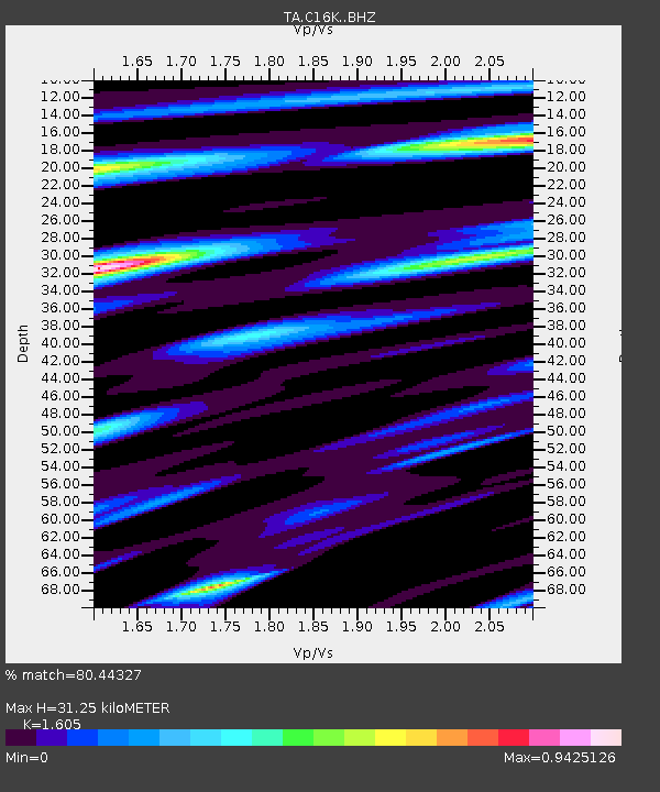
| Estimated Moho Depth: |
31.25 km |
| Estimated Crust Vp/Vs: |
1.61 |
| Assumed Crust Vp: |
5.906 km/s |
| Estimated Crust Vs: |
3.68 km/s |
| Estimated Crust Poisson's Ratio: |
0.18 |
|
| Radial Match: |
80.44327 % |
| Radial Bump: |
400 |
| Transverse Match: |
71.70395 % |
| Transverse Bump: |
400 |
| SOD ConfigId: |
13570011 |
| Insert Time: |
2019-05-02 08:57:16.453 +0000 |
| GWidth: |
2.5 |
| Max Bumps: |
400 |
| Tol: |
0.001 |
|
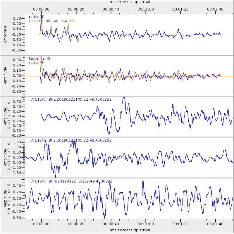
Signal To Noise
| Channel | StoN | STA | LTA |
| TA:C16K: :BHZ:20190122T05:22:49.450029Z | 4.7349935 | 8.505142E-7 | 1.796231E-7 |
| TA:C16K: :BHN:20190122T05:22:49.450029Z | 0.5833379 | 1.1443359E-7 | 1.9617033E-7 |
| TA:C16K: :BHE:20190122T05:22:49.450029Z | 2.3820481 | 2.1605359E-7 | 9.0700766E-8 |
| Arrivals |
| Ps | 3.3 SECOND |
| PpPs | 14 SECOND |
| PsPs/PpSs | 17 SECOND |


