You are here: Home > Network List > TA - USArray Transportable Network (new EarthScope stations) Stations List
> Station F23A Volborg, MT, USA > Earthquake Result Viewer
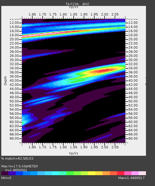
F23A Volborg, MT, USA - Earthquake Result Viewer
| Earthquake location: |
Kuril Islands |
| Earthquake latitude/longitude: |
46.0/151.4 |
| Earthquake time(UTC): |
2009/04/18 (108) 19:17:58 GMT |
| Earthquake Depth: |
35 km |
| Earthquake Magnitude: |
6.3 MB, 6.3 MS, 6.6 MW, 6.4 MW |
| Earthquake Catalog/Contributor: |
WHDF/NEIC |
|
| Network: |
TA USArray Transportable Network (new EarthScope stations) |
| Station: |
F23A Volborg, MT, USA |
| Lat/Lon: |
45.72 N/105.41 W |
| Elevation: |
953 m |
|
| Distance: |
66.4 deg |
| Az: |
48.114 deg |
| Baz: |
312.22 deg |
| Ray Param: |
0.05759361 |
| Estimated Moho Depth: |
17.5 km |
| Estimated Crust Vp/Vs: |
1.69 |
| Assumed Crust Vp: |
6.242 km/s |
| Estimated Crust Vs: |
3.704 km/s |
| Estimated Crust Poisson's Ratio: |
0.23 |
|
| Radial Match: |
92.59103 % |
| Radial Bump: |
340 |
| Transverse Match: |
72.99377 % |
| Transverse Bump: |
371 |
| SOD ConfigId: |
2658 |
| Insert Time: |
2010-03-06 19:35:59.320 +0000 |
| GWidth: |
2.5 |
| Max Bumps: |
400 |
| Tol: |
0.001 |
|

Signal To Noise
| Channel | StoN | STA | LTA |
| TA:F23A: :BHZ:20090418T19:28:13.500007Z | 16.534523 | 3.5724202E-6 | 2.1605824E-7 |
| TA:F23A: :BHN:20090418T19:28:13.500007Z | 1.8421266 | 8.7713386E-7 | 4.7615285E-7 |
| TA:F23A: :BHE:20090418T19:28:13.500007Z | 2.8506413 | 8.3403137E-7 | 2.9257677E-7 |
| Arrivals |
| Ps | 2.0 SECOND |
| PpPs | 7.2 SECOND |
| PsPs/PpSs | 9.2 SECOND |


