You are here: Home > Network List > TJ - Tajikistan National Seismic Network Stations List
> Station GARM Garm, Tajikistan > Earthquake Result Viewer
GARM Garm, Tajikistan - Earthquake Result Viewer
| Earthquake location: |
Sumba Region, Indonesia |
| Earthquake latitude/longitude: |
-10.5/119.0 |
| Earthquake time(UTC): |
2019/01/22 (022) 05:10:03 GMT |
| Earthquake Depth: |
27 km |
| Earthquake Magnitude: |
6.4 Mww |
| Earthquake Catalog/Contributor: |
NEIC PDE/us |
|
| Network: |
TJ Tajikistan National Seismic Network |
| Station: |
GARM Garm, Tajikistan |
| Lat/Lon: |
39.00 N/70.32 E |
| Elevation: |
1305 m |
|
| Distance: |
66.9 deg |
| Az: |
320.459 deg |
| Baz: |
126.524 deg |
| Ray Param: |
0.057280373 |
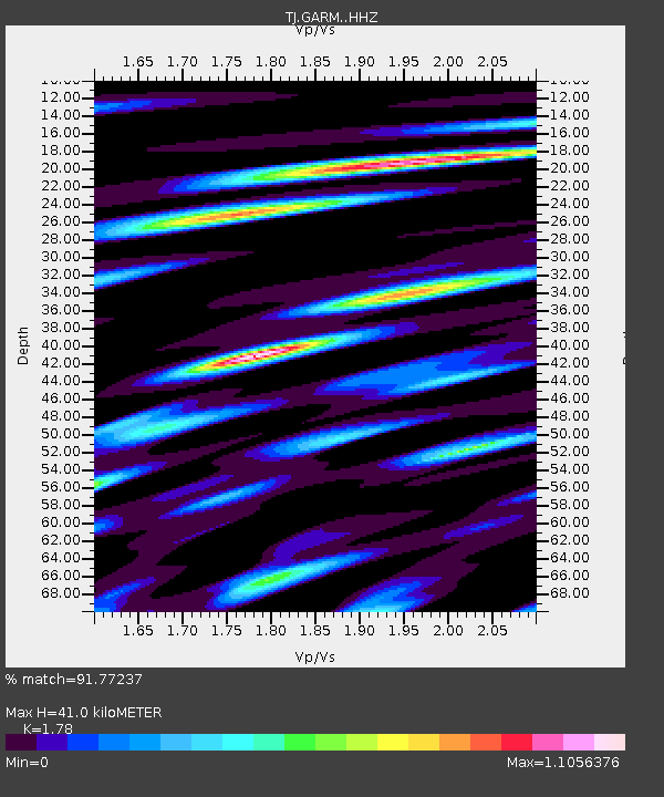
| Estimated Moho Depth: |
41.0 km |
| Estimated Crust Vp/Vs: |
1.78 |
| Assumed Crust Vp: |
6.306 km/s |
| Estimated Crust Vs: |
3.543 km/s |
| Estimated Crust Poisson's Ratio: |
0.27 |
|
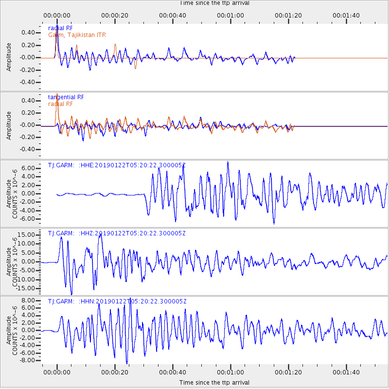
| Radial Match: |
91.77237 % |
| Radial Bump: |
400 |
| Transverse Match: |
85.56149 % |
| Transverse Bump: |
400 |
| SOD ConfigId: |
13570011 |
| Insert Time: |
2019-05-02 08:57:53.175 +0000 |
| GWidth: |
2.5 |
| Max Bumps: |
400 |
| Tol: |
0.001 |
|
Signal To Noise
| Channel | StoN | STA | LTA |
| TJ:GARM: :HHZ:20190122T05:20:22.300005Z | 40.00388 | 8.177189E-6 | 2.0440989E-7 |
| TJ:GARM: :HHN:20190122T05:20:22.300005Z | 10.3885 | 2.1430606E-6 | 2.0629163E-7 |
| TJ:GARM: :HHE:20190122T05:20:22.300005Z | 14.060399 | 2.4700423E-6 | 1.7567369E-7 |
| Arrivals |
| Ps | 5.3 SECOND |
| PpPs | 17 SECOND |
| PsPs/PpSs | 23 SECOND |


