You are here: Home > Network List > TA - USArray Transportable Network (new EarthScope stations) Stations List
> Station F23A Volborg, MT, USA > Earthquake Result Viewer
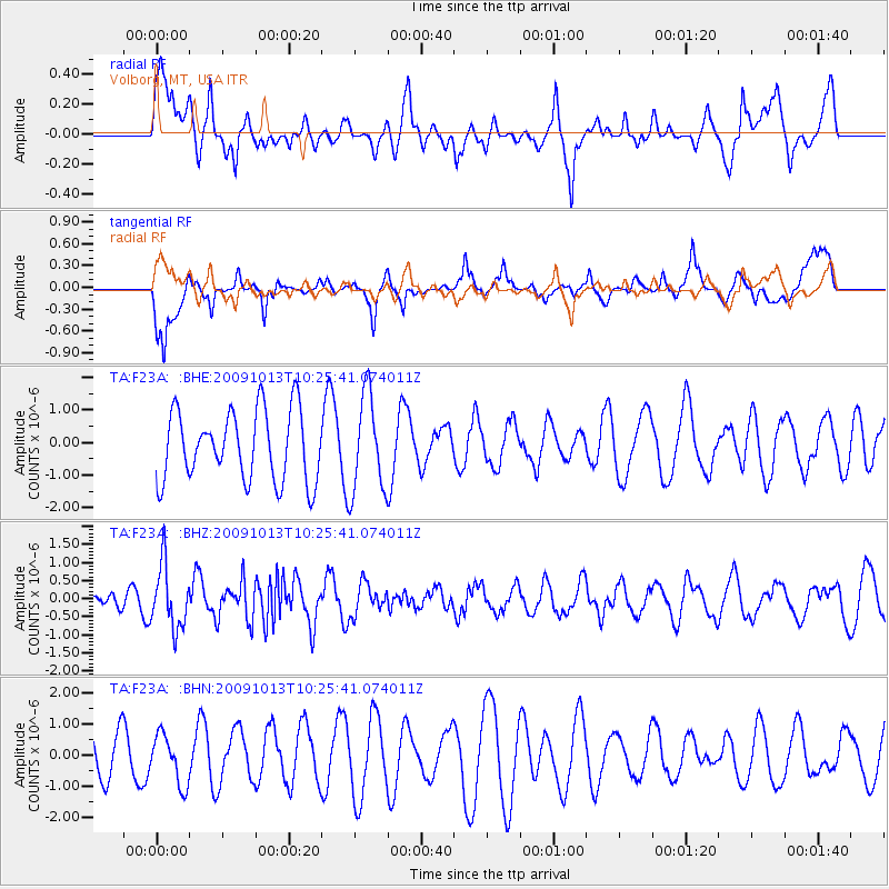
F23A Volborg, MT, USA - Earthquake Result Viewer
*The percent match for this event was below the threshold and hence no stack was calculated.
| Earthquake location: |
Kuril Islands |
| Earthquake latitude/longitude: |
44.6/149.1 |
| Earthquake time(UTC): |
2009/10/13 (286) 10:15:13 GMT |
| Earthquake Depth: |
40 km |
| Earthquake Magnitude: |
5.6 MB, 5.2 MS, 5.7 MW, 5.6 MW |
| Earthquake Catalog/Contributor: |
WHDF/NEIC |
|
| Network: |
TA USArray Transportable Network (new EarthScope stations) |
| Station: |
F23A Volborg, MT, USA |
| Lat/Lon: |
45.72 N/105.41 W |
| Elevation: |
953 m |
|
| Distance: |
68.6 deg |
| Az: |
46.504 deg |
| Baz: |
312.267 deg |
| Ray Param: |
$rayparam |
*The percent match for this event was below the threshold and hence was not used in the summary stack. |
|
| Radial Match: |
44.472248 % |
| Radial Bump: |
400 |
| Transverse Match: |
46.34904 % |
| Transverse Bump: |
400 |
| SOD ConfigId: |
2622 |
| Insert Time: |
2010-03-06 19:36:42.488 +0000 |
| GWidth: |
2.5 |
| Max Bumps: |
400 |
| Tol: |
0.001 |
|
Signal To Noise
| Channel | StoN | STA | LTA |
| TA:F23A: :BHZ:20091013T10:25:41.074011Z | 3.0843525 | 8.649815E-7 | 2.8044184E-7 |
| TA:F23A: :BHN:20091013T10:25:41.074011Z | 0.84881943 | 7.8519315E-7 | 9.2504143E-7 |
| TA:F23A: :BHE:20091013T10:25:41.074011Z | 1.3879207 | 1.4905931E-6 | 1.0739757E-6 |
| Arrivals |
| Ps | |
| PpPs | |
| PsPs/PpSs | |


